Kalpeshwar Trek – A Complete Guide
Table of Contents

Where is Kalpeshwar?
Kalpeshwar (2,200 metres, approximately) is a Hindu temple dedicated to Lord Shiva located in the Chamoli district of Uttarakhand. It is the Fifth Kedar to be visited, in case you are staying true to the sequence of the Panch Kedar circuit. The other four being Kedarnath , Madhmaheshwar , Tungnath , and Rudranath. It is also the only one (of the five temples) that stays open throughout the year. The rest close down for the winter a day or two after the festival of Diwali.

What is the motorable route?
Haridwar – Rishikesh – Devprayag – Srinagar – Rudraprayag – Karnaprayag – Nandprayag – Chamoli – Pipalkoti – Helang – Lyari – Devgram
Total Distance – 275 kilometres, approximately
Earlier, the trek to Kalpeshwar started from Lyari as the road till Devgram was still under construction. Now, I’m told, the road has been completed although it’s not a firm one and not always open.
The road from Haridwar to Helang is more or less well-maintained except for a few patches that fall under the landslide zone.
But it is not going to be a cakewalk driving from Helang to Devgram. It is not a road but a trail of loose (mostly) soil and rocks that is prone to breaking apart. It is advised that you keep driving till Joshimath (14 kilometres from Helang) , park your vehicle there and then take a shared jeep to Devgram via Helang. Unless you are a pro at off-roading!
This more than sorts it out in case you are driving your own vehicle or a self-drive vehicle.

In case I want to opt for public transport?
- Take a bus or shared taxi (Max) from Haridwar/Rishikesh to Joshimath
- Get down at Helang and take a shared taxi (Max) to Lyari/Devgram
Please note that almost all of the taxis to Devgram ply from Joshimath and aren’t as frequent as to other popular places. You might have to wait it out at Helang. Alternatively, you can get down at Joshimath and stay there for the night. Next morning, take a shared taxi from Joshimath to Devgram. If you don’t like to wait it out and have money to spare, you can book the entire vehicle (from Joshimath) at around INR 500-600 for one way.
Buses, both local and of Uttarakhand State Transport, and shared taxis start plying from Haridwar/Rishikesh to Rudraprayag and further as early as 4 am.
It should cost one person INR 1200-1400, Haridwar to Haridwar .
How long is the trek? How is the trek route like? Do I need a guide?
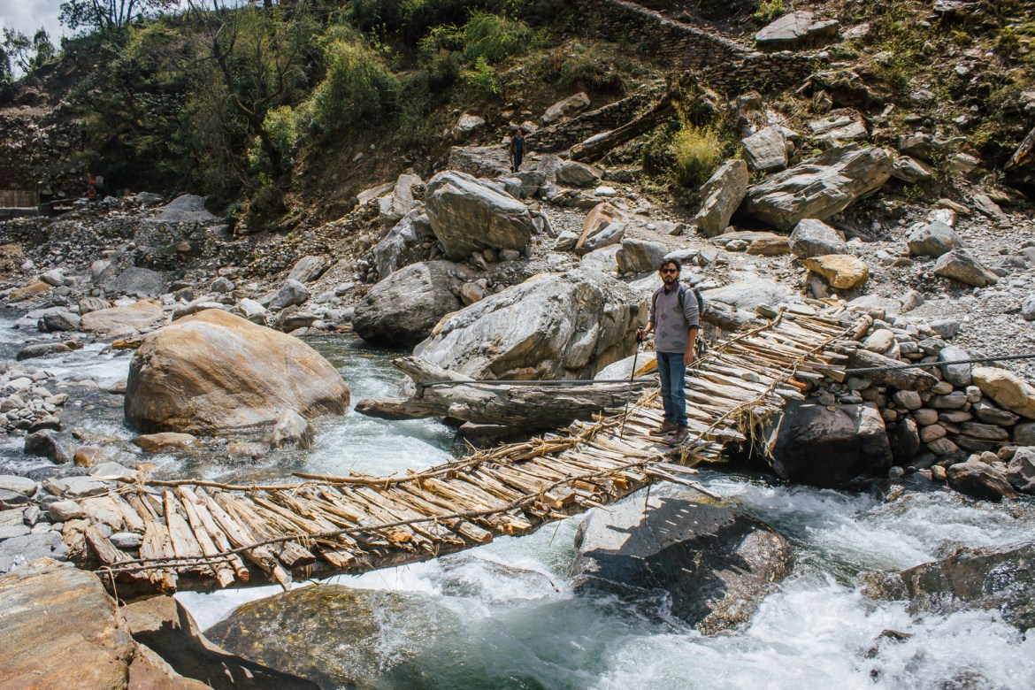
The trek from Lyari to Kalpeshwar is barely 2 km , whereas from Devgram to Kalpeshwar it is less than 500 m and pretty straight forward, passing through the gorgeous Urgam Valley. Most of the route is paved with little to no ascent. Reach till the end of the village, a curve from where the path descends towards the river. You will see a short ascent on the other side of the river, left to the waterfall, and leading up to Kalpeshwar temple, neatly hidden between the rocks. Walk down and take the little wooden bridge to reach to the other side.
If you start early, you can make it back to Joshimath by afternoon quite easily. You do not need a guide.

Where to stay and how much will it cost?
There are a decent number of guest houses and lodges in Devgram where you can get a room for about INR 300-400 for two . The vibe here is inherently different than rest of the four Kedar combined. Even though the trek is short-lived, Urgam Valley makes it up with its chilled-out demeanour and ever-so-smiling locals.
If you wish to come back to Joshimath the same day, there are plenty of options, the cheapest one being the dormitory beds at GMVN, available for INR 300 per person . And if budget is not a constraint, you can also go for luxury cottages, and a few small guest houses and resorts at Auli , 25 km from Devgram.
This is the gist of it. If you have any further queries, feel free to leave a comment below. I’ll get back to you as soon as I can. Stay safe, travel responsibly!

Photographer by day. Travel Writer by night. And a Copywriter in between.
You may also like
Kedarnath trek – a complete guide, the pahadi organic – a true-blue pahadi experience, tungnath trek – a complete guide, char dham yatra – finding devotion in destruction, pindari glacier trek – ringing in the new..., deoria tal – of epics, myths, and the..., deoria tal trek – a complete guide, chandrashila – why this should be your first..., binsar – romancing old-world wilderness and the himalaya, madhmaheshwar trek – a complete guide, leave a reply cancel reply, 22 comments.

That’s pretty much all the info summed up. How many days would it take to complete the trip from Delhi-Kalpeshwar-Delhi? And what is the best time to visit?
Would appreciate the info.
TanksT Sumit S
Hi. Thanks for writing in. It should take 3-4 days, Delhi-Kalpeshwar-Delhi. It is open through the year so depends on your preference. Personally, I’d recommend Oct-Nov. Also, there has been a correction. Request you to read it once before planning.

Hi Mohit, I am planning Kalpeswar and Tunganath with kids in May 2020. Please advice an itenary and also nearby places to halt after I visit these two place Aparna.
Hi Aparna. Apologies but I don’t do itineraries. Tunganath-Kalpeshwar-Badrinath should be ideal.

Good information.pls Tell me the opening and closing time of the kalpeswar temple.is it open through out the year. Can I get Jeep on share from Helang both up and down. Can I get bus to Josimath from Helang.
Temple is open throughout the year. As I have written, it is better to take a jeep from Joshimath.

Thanks For Sharing The Information. Very Helpful
Kedarnath Tour
Glad to be of help!

Worthy description!

Is guide and mule available at Urgam for treking to kalpeswar and Rudranath and sagar
You don’t need a guide or mule while trekking to Kalpeshwar. You will get them both for Rudranath though, at Urgam.

I’m planning for kalpeshwar 3rd week of December. Is it feasible?
Quite feasible. The trek itself should take you only about an hour.

Dear Mohit,your post is excellent about Kalpeshwar.I want to stay in Joshimath and want to go to Kalpeshwar in Dec probably in second week.Can you please tell me whether it is OK in that time.
Hi. Apologies for a late response. I hope by now you’ve sorted this out and also heard the news about Joshimath.

This October-end we are planning for Madhya Maheshwar. While coming back from Ransi village to Haridwar on the same day, can we visit Kalpeshwar on the way. Need your suggestion.
Kalpeshwar is not on the way to Haridwar. It is not possible.

Your writing contains everything. Just 1 QQ. Is the Trek to Kalpeshwar possible for a solo traveller?
Yes, absolutely.

if I start at 9am Dehradun, can i see Kalpeshwar and come to Gopeshwar or Sagar village in time ? as i will like to go for Rudranath trekking on next day
That’s not possible.
Kalpeshwar Rudranath Trek

Can You Help Us With Photographs Of This Trek?
We are looking to enrich this documentation with more photos. Pictures go a long way in explaining the trail, more than words ever can. If you have done this trek, can you share your photos with us? We will include them on this page, with due credit to you. Click here to contribute .
The Complete Guide to Kalpeshwar Rudranath Trek
- A trek with all colours of mother nature – Vibrant, Serene and Fascinating. The trail covers two of the five Kedar’sKalpeshwar and Rudranath situated in Uttrakhand. The Kalpeshwar Rudranath trail offers splendid views as it passes through thick woods, green valleys, lush green meadows, beautiful wild flower beds and high ridges.
The trail is well defined through village’s en-route with extremely charismatic views. One can easily get lost in mesmerizing views of the magnificent peaks of Nanda Devi, Trishul and Nanda Ghunti.The initial trail from Devgram to Bansi Narayan is strenuous vertical climb of around 1500 mtr.
However the strenuous vertical climb is rewarded by the grand campsite, surrounded in the clouds, over the colourful flower beds with Bird’s-eye view of lush green meadow and snow-capped Himalayan peaks in the front.From there on to Dumak is an easy trail down the valley passing through Kalgoat.
The trail from Dumak to the high meadows at Panar is demanding, with long, hard climbs, sometimes through leech infected zones especially during and immediately after monsoons. The trail further is easy and offers grand views of the Alpine meadows and deep gorges full of wild colourful flowers and heavenly hamlet. From the ridge between Panar and Rudranath one can see Alaknanda carving its way down to the plains, and the mistysilhouettes of the foothills.
General Information
MYTH -The legend of PanchKedar, is aninteresting narration of the efforts of Pandavas to atone for the sins of their fratricide (gotra- hatya) act of killing their cousins, the Kauravas, and Brāhmanahatya (killing of Brahmins - the priest class), during the epic Mahabharata war.
On advice from sages and their trusted benefactor god Krishna they sought Lord Shiva to pardon them and bless them to attain salvation. Since Shiva was annoyed with them for their conduct during the Kurukshetra war, he tried to avoid them by assuming the animal form of a bull or Nandi and hid himself in the Himalayan Garhwal region.
But the determined Pandavas, after sighting Shiva in the form of the bull grazing in the hills of Guptakashi, tried to forcibly hold the bull by its tail and hind legs. But the bull disappeared into the ground to reappear later in his original self of Lord Shiva at five places; in the form of a hump at Kedarnath, in the shape of bahu (arms) at Tungnath, with his face at Rudranath, his nabhi (navel) and stomach at Madhyamaheshwar and his hair (locks) called jata at Kalpeshwar.
Pandavas, pleased with the revelation of Lord Shiva at five places in different forms, built temples at these five places, worshipped him and attained salvation with blessings of Shiva. The temples were later discovered by AdiSankaracharya.
Kalpeshwar houses the famous Kalpavriksha. This tree is believed to fulfill all the wishes of a person. There is a cave temple situated at height of 2134 mtr and Shiva is worshiped here in his matted hair form. Kalpeshwar is surrounded by dense woods and also terraced fields that lie in the Urgam valley.
Rudranath is situated amidst thick woods, here the 'mukh' or the Lord's face appeared and Shiva is worshipped as Neelkanth Mahadev. All around the temple are fragrant flower laden meadows. In the background, are the glittering snow-covered peaks of Trishul, Nanda Devi, NandaGhunti. Near the temple is a stream of sparkling water known as Vaitarini - the 'Water of Salvation'. The temple is surrounded by a number of pools - Surya Kund, Chandra Kund, Tara Kund andManasKund - while the great peaks of Nanda Devi, Trishul and Nanda Ghunti rear overhead.
Short Itinerary
- The trail is well defined through village’s en-route with extremely charismatic views. One can easily get lost in mesmerizing views of the magnificent peaks of Nanda Devi, Trishul and Nanda Ghunti.The initial trail from Devgram to Bansi Narayan is strenuous vertical climb of around 1500 mtr.View golden sun rays shining on the snow capped Himalayan peak
➤ Detailed Itinerary
Day 1Drive from Rishikesh to Helang; 8-9 hours, 241 kmHelang to Devgram; 1 hour drive + 30 minutes trekDay 2Acclimatisation day; Trek to Kalpeshwar; 2-3 hoursDay 3Devgram (6,627 ft) to Bansi Narayan (11,482); 8-10 hours, 12 kmDay 4Bansi Narayan (11,482) to Dumak (7,874 ft); 5-6 hours, 10 kmDay 5Dumak (7,874 ft) to Panar (11,155 ft) via Toli (9,186 ft); 6-8 hours, 12kmDay 6Panar (11,155 ft) to Rudranath (11,811 ft) and back; 7-9 hours; 14 kmDay 7Panar (11,155 ft) to Sagar (6,561 ft); 4-5 hours, 12 km
Day 1: Reach Devgram
- Altitude: 6,627 ft
- Time taken: 10-12 hours drive; 30 minute trek
- Trail type: Initially a paved mud track which becomes cemented as you approach the village.
The journey to Devgram involves 3 steps. You first need reach Helang from Rishikesh, which is an 8-9 hours drive. From Helang, take a shared jeep to Devgram, in Urgam district. It should take you about an hour to reach Devgram. The last 2 km need to be trekked.
The initial trail is a stone paved mud track through green valleys. As you move closer to the village the trail becomes a cemented track. You can see terraced fields and settlements spread across the hills. You occasionally see villagers working in the fields. On the way, you will get a natural water tap shaped in the form of a cow's mouth. Water flows through this all day.
Close to Helang, you'll get to see the beautiful confluence of Alaknanda and Kalpganga rivers.

Devgram village
There are many guest houses in Devgram that offer accommodation and food at nominal rates.
Day 2: Acclimatisation Day; trek to Kalpeshwar and back
- Altitude: 7,217 ft
- Time taken: 2-3 hours
- Trail type: Easy. Initial ascent for 20-25 minutes followed by level walk for 10 minutes. Last 10-15 minutes is an ascent on steps.
- Water sources: Carry 1 litre of water. You'll cross a river around midway, where you can refill
Prathik Lodge
The trek to Kalpeshwar helps with acclimatisation. This is important because you will trek to Bansi Narayan on Day 3, which is at an altitude of 11,482 ft.
The trail from Kalpeshwar starts near Prathik lodge in Devgram. The trail initially climbs up a cemented track through settlements and fields. You will pass through green valleys in about 15 minutes. Proceed keeping to the left of the valley. In 5-10 minutes, you will see a waterfall ahead in the distance.
At this point, the trail becomes level. You walk through lush meadows. You can see the Kalpganga river to your right. This can also be used as a camping site if you wish to camp rather than stay in the village.

Kalpeshwar Rudranath suspension bridge
In another 5 minutes, you will reach a suspension bridge. You will find the steps going up to Kalpeshwar temple once you cross the bridge.
Return to Devgram on the same trail. You will find plenty of birds and flowers en route.
Day 3: Devgram to Bansi Narayan
- Altitude: 6,667 ft to 11,482 ft
- Time taken: 8-10 hours, 12 km
- Trail type: Moderate. Gradually ascending all the way to Bansi Narayan
- Water sources: Carry 2 bottles of water. First source is a stream at Bansa village, 1.5 hours into the trek. Second one is at Bansi Narayan temple, 4 hours away.
Start early today. Eat breakfast before leaving and also carry packed lunch since you will not find any place on the way to buy food.
From Prathik lodge, take the trail going towards the left. The trail passes through terraced fields where villagers grow rajma (kidney beans) and potatoes. This is all part of the Urgham valley. After 15-20 minutes of gradually ascending up this trail, you can spot settlements spread across the valley. Another 10-15 minutes of trekking bring you to a water – wheel. This channels water through a narrow stream call baanchaki or Gharat system to grind grains. Continue on this trail. In 40 – 45 minutes you reach Bansa village.
Bansa village has a beautiful Urvashi temple. This is right next to the water stream. You can take a break here if you wish. The stream water is clean and can be used to refill water bottles.

Kalpeshwar Rudranath temple
Near the temple, there is a sign which says “Bansi Narayan temple 10 kms from here” written in local language. Proceed from the temple and you will soon see a bridge. Take the ascending trail that you get after crossing the bridge. Stay to the left of the stream. The trail now gradually climbs up a ridge. In about 40 minutes, you will come across a small stone temple on the right side of the ridge. Continue on the trail, which now enters a thick forest. The mud trail moves up in a zig-zag way. As you move up the slope the woods get thicker. You will occasionally come across a few boulders. However, through all this, the trail is well defined. At places, it is bounded by a stone wall.
In about 45-50 minutes, you will come across a few boulders on the left side of the trail. This is a good spot to have lunch.
From here, the trail climbs up rather steeply now through dense woods. The mud trail is very pleasant through dense oak forest. The valley widens in about 45 minutes. You reach a clearing and get your first clear views of the Himalayan range around.
Around 30 minutes more on this trail brings you the top of the ridge. The trail now moves slightly towards your left. Within a few minutes you reach the Bansi Narayan temple. It takes around 7 - 8 hours to reach this point.
Bansi Narayan temple is surrounded by huge boulders. It is a single structure, built of stone. It is an ancient temple dedicated to the Hindu God, Vishnu.
Some of the overhanging boulders around the temple provide temporary shade. There is a small stream a few minutes from the temple. This is the only water source here. You can pitch tents here or proceed ahead to the natural cave that can accommodate around 30 – 40 people.

Kalpeshwar Rudranath trek boulders
The cave is 25 – 30 minutes of gradual climb through lush green meadows and colorful wildflowers which are in full bloom in the months of August and September. The trail to the cave crosses the huge boulders beyond the temple. It moves first towards the right and then towards the left. The cave is to your right on this trail. You will see pink wildflowers in full bloom spread over the entire slope just before the cave. It is a little difficult to find the cave since it is middle between boulders spread across the meadows. You get mesmerizing views of snow-capped Himalayan peaks such as Nandadevi, Trishul, Dronagiri, Nandaghunti from the cave.

Lush green meadow at Bansi Narayan
Day 4: Bansi Narayan to Dumak
- Altitude: 11,482 ft to 7,874 ft
- Time taken: 5-6 hours, 10 km
- Trail type: Easy. Gradually descending all the way to Dumak
- Water sources: Carry 2 bottles of water. First source is a stream at Bansi Narayan temple, 15 minutes into the trek. The second source is a stream around 40 minutes into the trek. The third water source is a stream outside Kalgoat, 1.5 hours into the trek.
Wake up early. Engulfed in clouds, Bansi Narayan Cave is an awesome campsite with splendid views of colorful wild flowers spread over lush green meadows with golden Himalayan peaks right in front.

Kalpeshwar Rudranath Trek - Dronagiri peak
Start on the trail back to Bansi Narayan temple. Once you cross the temple, the trail moves to the ridge to the right. You will enter the dense forest in 5-10 minutes. Continue on the mud trail keeping towards the right of the valley. This is a gentle downhill walk through overgrowth and thickets covered with colorful wildflowers. In another 10 minutes, you will cross a stream. The water is good to drink.
The trail, in this section, is shaded by gigantic chestnut trees. You come across a few fallen trees which require a little bit of scrambling to cross over. You will also have to cross a few boulders. Varieties of ferns and fungi appear on the way. At this point, the descent becomes steeper. You will enter a dense oak forest. After 45-50 minutes, the Alaknanda valley opens up ahead. This is Kalgoat village. You can take a break here.

Downhill walk through dense woods
Dumak is around 7 km from Kalgoat. The trail from Kalgoat village to Dumak village is well marked and takes 2 – 3 hours. Continue on the trail that passes through huge boulders and shrubs. 20 – 30 minutes of hike across the village brings you to an old Mahadev temple built of stone. This temple is at the other end of the village - the Dumak side. Just before the temple is a narrow bridge over a small stream - the water here is good to drink. After crossing the bridge you will find a bell and prayer flags tied to a pole.

En route Kalgoat to Dumak
The construction of the poles is such that it forms an entry gate. A new shade has been put up in front of the old stone temple. Continue on the trail that passes through woods and shrubs. If you’re lucky, you might spot a monal. It’s a level walk now. Dumak village becomes visible in the distance after about an hour. Terraced fields appear around you. Also visible are water channels to the fields. You will reach a blue signboard for a pre-primary school in about 40 minutes.
You can either stay at Bhandari guest house, which is around 5 minutes ahead on the trail or camp next to the stream, a little ahead. Bhandari guest house can provide basic food and stay arrangements at a nominal price.

Day 5: Dumak to Panar via Toli
- Altitude: 7,874 ft to 11,155 ft via 9,186 ft
- Time taken: 6-8 hours, 12 km
- Trail type: Initial level trail for 25 minutes followed by 45 minutes of steep descent. 3 hours of ascent to Panar from Toli.
- Water sources: Streams along the trail
Start early since it will be a long day. Take the cemented trail that leads out of Dumak village on the other side. It passes through terraced fields. In about 25 minutes, you will reach the end of the ridge. Here, take the trail that goes to the right. This is a narrow mud trail which descends steeply. Stay at right side of the valley. Rudra Ganga river becomes visible in 20-30 minutes.
You will reach the river in about 45 minutes. The view of the river as you cross it over the cemented bridge, is stunning. This is a good spot to take a break and refill your water bottles.

River flowing down the thick woodlands
After crossing the river, the trail moves towards the right, ascending into the woods. After 20-30 minutes, the trail becomes level. It turns left, where you will cross a few streams. Continue on the trail that ascends from here. It keeps getting steeper. You will notice it climbing up a ridge in 25-30 minutes. In about 45 minutes, you will reach the end of the ridge, and enter the huge meadows of Toli.

The trail up from the river till Toli is infested with leeches, especially in the months of August and September. Toli has huge green grasslands with a beautiful alpine lake, surrounded by thick forest. You can also see a few temporary settlements used by the shepherds. The meadows of Toli are filled with cattle grazing in the summer and monsoon. This is a good place to break for lunch.
From Toli, the path becomes a little tricky. There are very few landmarks. Continue on the trail that moves towards your right. The trail gently climbs up the ridge. You almost reach the end of the ridge in 30-40 minutes. You will see a small meadow over the ridge.

Toli tal meadow
Here, the trail moves to your left. It traverses the meadow and gently climbs up a ridge. Keep climbing up to the left till the ascent that becomes steeper. After 45-50 minutes, you notice the vegetation becoming thinner. Continue on this trail till you reach the top of the ridge. From here, the path moves around the mountain to your right to the sloping meadows of Panar (11,155 ft). It takes 2-3 hours from Toli and 6-8 hours from Dumak to reach Panar.
Panar has a tourist hut and a shepherd settlement nearby. Both provide food. Pilgrims also stay in the cave which is a few metres above the Panar meadows on the route to Rudranath. From Panar you can see beautiful snow capped mountains of Nanda Devi, Trishul and Nanda ghunti and the Bandarpoonch massif. In the month of August and September Panar turns into a carpet of pinkish red flowers. There is a thin water stream a few metres below the tourist hut. The water from the stream can be used for drinking and cooking.
Day 6: Panar - Rudranath - Panar
- Altitude: 11,155 to 11,811 ft to 11,155 ft
- Trail type: Moderate. Gradually ascending trail to Rudranath.
- Water sources: None till you reach Rudranath. Carry 2 litres of water.
Start in the morning, after breakfast. Take the trail that moves towards the ridge to the left. You will see some huge boulders and snow-capped peaks to your left.

Panar meadow
The trail gradually climbs up the ridge. You will notice some undergrowth on the way. After 25-30 minutes of ascent, you can see the Panar meadows below. In another 30-40 minutes, you reach a huge overhanging boulder on the left. From here, the scene is magnificent - the vast green meadows of Panar below and snow-capped peaks in front, engulfed in clouds.
Continue on the trail that climbs up the ridge. As you climb up you see huge boulders on the right and in the front.

Kalpeshwar Rudranath trek peaks
Continue on the trail, till you see huge boulders on the left and a lush green valley on the right. It takes around 1.5 – 2 hours to reach here. You will shortly reach a stretch where there are huge boulders on either side of the trail. From here, the trail is well defined. This is a stone path, mostly a gentle trail with a few gradual ascents. This ridge between Panar and Rudranath has unmatched views of the Himalayas. You are surrounded on all sides by snow-capped peaks and lush green valleys.

Meadows on the way
A narrow ridge on the left connects Rudranath to Mandal forest and Anusuya temple. This is a beautiful trail that passes through the Mandal forest. You have the option of taking this trail on your way back from Rudranath.
Proceed ahead on the trail. You are now surrounded by colorful flowers and shrubs. Notice the temporary shepherd settlement made of stone to your left. Continue on the mud trail that gradually ascends, keeping the valley to your left. You will soon see prayer bells and flags in the distance. It takes 15-20 minutes to reach them.

Kalpeshwar Rudranath trek highest point
This is the highest point on this trail. It takes 3-3.5 hours to reach here from Panar. The trail now descends into the valley. You see bright flowers and shrubs around. This valley is known for medicinal herbs. Continue on the trail as it climbs up a ridge. Spread over a couple of hundred meters on either side of the ridge are colorful wildflowers and a lush green meadow.

Rudranath shrine
Rudranath shrine becomes visible at a distance after an hour of hike. The trail descends first and then ascends. In 25-30 minutes you will reach a brightly painted tourist hut. It has 2 rooms that are used by pilgrims and tourists who wish to stay overnight at Rudranath.

Rudranath temple
Continue past the tourist hut. In a few minutes you will come across a small stone idol and a temple dedicated to Devrishi Narad. Further up the trail notice settlements to the left. These belong to the temple priest and locals.The Rudranath shrine will be to your left and the lush green valley, to your right. It takes around 4.5 hours to reach here from Panar. Rudranath shrine is surrounded by huge rock walls and boulders. It is bounded on each side by a pond - Surya Kund, Chandra Kund, Tara Kund and Manas Kund. The Bandarpoonch range is very prominent from here. There are places around the temple that serve lunch. Return to Panar after lunch.
Day 7: Panar - Sagar
- Altitude: 11,155 to 6,561 ft
- Time taken: 4-5 hours, 12 km
- Trail type: Easy. Gradual descent all the way.
- Water sources: Carry 2 bottles of water from Panar
Start after breakfast. Take the stony mud trail descending to the left from Panar. This brings you down the ridge in a zig-zag manner. The grasslands of Lunti Bugyal become visible in 15-20 minutes. You will reach Lunti Bugyal in another 10 minutes.

Rudranath stream
From Lunti Bugyal, continue on the trail that moves towards your left. The trail enters a dense forest in 15-20 minutes. This is now a mud trail but it is well defined. You will reach a water stream in 45 minutes. Cross it over the cement bridge. The trail descends into woods after the bridge. A beautiful meadow becomes visible in the distance in 25-30 minutes. It will take you another 15 minutes to reach this meadow. It is surrounded by forests on all sides.

Sakleshwar Mahadev Mandir
You will find a few tea stalls here that sell tea and snacks to pilgrims. A shade has been put up to shelter tourists from rain and sun. Colorful flags mark the boundary of the area.
Continue on the trail that enters another forest from the meadow. In 30-45 minutes, the forest clears and you will see terraced fields to your left. Sagar also becomes visible. Continue moving down the well-defined trail that moved through the fields. There is a stream just before Sagar. From here, the trail becomes narrow and passes through rocky steps all the way to Sagar.

Sagar bus stop
The trail passes through shops and huts before reaching the road. The bus stop is at the end of the steps that lead to the trail. On the other side of the road is the entrance to the Sakleshwar Mahadev Mandir. The Mandal – Gopeshwar road passes through Sagar village and you can get shared jeeps/buses going to Gopeshwar from here. It is around 5 km from Sagar village. From Gopeshwar one can go to Chamnoli village from where you can get frequent buses to Haridwar and Rishikesh.
How to Get Fit for the Trek

Cardiovascular endurance This trek requires a good amount of endurance. You can begin by jogging everyday . Start jogging at a slow pace and then keep increasing your pace day by day. Make sure you are able to jog 4 km in 20 minutes before the start of the trek. It takes time to be able to cover this distance in the given time. Swimming, cycling and stair climbing without too many breaks in between can help too.
Strength This is another area you should work on. There is a lot of trekking distance that you will cover carrying your backpacks and trekking along with your backpack is not a very easy task. You have to walk on uneven terrain during the trek. It could be taxing for your legs. For this, strengthening your legs will help. You can do some squats to strengthen them. Do around 3 sets of squats, with 8 squats in each set .
Flexibility Another aspect that will help you trek comfortably is flexibility. For this, you can do some stretching exercises - stretch your hamstrings, quadriceps, hip flexors, lower back muscles and shoulders regularly. On your trek, it is important that you arrive on the slopes with your muscles relaxed. Carrying a backpack, however light, can become a strain after a while. These exercises will help you to be in good shape before the trek.
Here's a guide to help you get fit for the trek.

Working out indoors If you can't go out and jog because of time and space constraints, here's a video you can use to work out indoors.
What to Pack for the Trek

Bare necessities
- Trekking shoes: The trek distance is long and you will have to walk for long distances which need you to have comfortable trekking shoes. You can watch this video to learn to choose the right trekking shoes .
- Backpack (40-60 litres): A backpack with sturdy straps and a supporting frame. Rain cover for backpack is essential.
The Kalpeshwar Rudranath trek happens in summer (Mid May-mid June) or post monsoon. So carry a poncho , in case you experience pre-monsoon showers or sudden rainfall post monsoon.
- Three (Five in Winter) Warm Layers: You will be trekking and camping at high altitudes. So make sure you have the apt clothes for the climatic conditions. It will be cold at the higher altitudes so make sure you have at least three layers of warm clothes to protect yourself.
- Two trek pants: One pair of pants should suffice for this trek. But you can carry one spare pair in case the first one gets wet. Wear one pair and carry one pair. Wear full length trek pants, especially if you plan to trek after monsoon. The trail is infested with leeches after monsoon in a few sections.
- Two collared t-shirts: Carry light, full sleeved t-shirts that prevent sun burns on the neck and arms. Again, wear one and carry one.
- Thermals (Optional): Those who are more susceptible to cold can carry thermals to wear at night.
Accessories
- Sunglasses: Sunglasses are to prevent snow blindness. There might be snow in Har Ki Dun Valley or from Kalkatiyadhaar (depending on the season you are going in), so carry a pair of sunglasses.
- Suncap : The sun is more harsh at high altitudes so wear a suncap to protect your face and neck.
- Synthetic hand gloves: One pair of fleece or woolen hand gloves. One pair of water proof/resistant, wind proof gloves.
- Balaclava : You may use woollen scarves instead as well.
- Socks (2 pairs): Apart from two sports socks, you can take a pair of woollen socks for the night.
- Headlamp/LED torch: Mandatory
- Trekking pole : Watch this video to understand why you need a trekking pole .
- Daypack (20 litres): If you are offloading your backpack, you will need a smaller backpack to carry water, medical kit and some light snacks.
- Toiletries ( Sunscreen , moisturiser, light towel, lip balm, toilet paper, toothbrush, toothpaste). If you intend to use wet wipes or sanitary napkins, carry a zip lock back to put the used napkins and wipes. Bring this back down with you from the trek. Do not dispose these items in the mountains.
- Cutlery: Carry a spoon, coffee mug and a lunch box. This is more hygienic.
- Two water bottles: 1 litre each
- Plastic covers: While packing, use plastic bags to compartmentalise things and carry few extra plastic bags for wet clothes.
Mandatory Personal Medical Kit
- Diamox - 10 tablets (to prevent AMS)
- Crocin – 6 tablets (fever)
- Avomine – 4 tablets (motion sickness)
- Avil 25mg – 4 tablets (allergies)
- Combiflam – 4 tablets (Pain killer)
- Disprin – 6 tablets (headache)
- Norflox TZ & Lomofen– 6 tablets each (diarrhea)
- Digene - 10 tablets (acidity)
- Omez/ Rantadine – 10 tablets (antacids)
- Crepe bandage – 3 to 5 meters
- Gauze - 1 small roll
- Band aid – 10 strips
- Cotton – 1 small roll
- ORS – 10 packets
- Betadine or any antiseptic cream
- Moov spray (aches, & sprains)
➤ Difficult Sections
The Kalpeshwar Rudranath trek is a moderate trek. The trail involves some steep ascents and descents, as well as walking through boulders.
➤ Trek Contribution
Author: Vinita Chattwani
Upcoming Treks

Bijli Mahadev Trek

Chandrakhani Pass Trek

Pin Bhaba Pass

Hampta Pass

MIYAR VALLEY TREK
Sign up for our much loved Weekly Mailer
We have terrific trekking tips, trek updates and trek talks to look forward to
Treks by Categories
Treks by season, treks by month, treks by duration, treks by difficulty.
- Easy - Moderate
- Moderate - Difficult
Treks by Region
- Uttarakhand
- Himachal Pradesh
- Lahaul and Spiti
- Jammu & Kashmir
- West Bengal
- Chhattisgarh
Treks by Experience
- Family Treks
- Stargazing Treks
- Senior Treks
- Adventure Therapy
- Summer Camps
- Youth Camps
- Cancellation policy
- Work with us
- Our sustainability practices
- Privacy Policy
- Terms & Conditions
080 468 01269 Mon to Sat - 9.30 AM to 7.30 PM Sun - 9.30 AM to 6.30 PM
Bengaluru Office
139, Defence Colony Road, Defence Layout, Sahakar Nagar, Bengaluru, Karnataka 560092
Dehradun Office
Mohabbewala, Titan Road, Near Titan Factory, Chandramani Khalsa Dehradun - 248002
© 2024 Indiahikes Private Limited
All images are copyrighted by their respective authors.
Kalpeshwar Trek - A Complete Guide

Where is Kalpeshwar?
Kalpeshwar (2,200 metres, approximately) is a Hindu temple dedicated to Lord Shiva located in the Chamoli district of Uttarakhand. It is the Fifth Kedar to be visited, in case you are staying true to the sequence of the Panch Kedar circuit. The other four being Kedarnath , Madhmaheshwar , Tungnath , and Rudranath. It is also the only one (of the five temples) that stays open throughout the year. The rest close down for the winter a day or two after the festival of Diwali.
Urgam Valley.

What is the motorable route?
Haridwar - Rishikesh - Devprayag - Srinagar - Rudraprayag - Karnaprayag - Nandprayag - Chamoli - Pipalkoti - Helang - Lyari - Devgram
Total Distance - 275 kilometres, approximately
Earlier, the trek to Kalpeshwar started from Lyari as the road till Devgram was still under construction. Now, I'm told, the road has been completed although it's not a firm one and not always open.
The road from Haridwar to Helang is more or less well-maintained except for a few patches that fall under the landslide zone.
But it is not going to be a cakewalk driving from Helang to Devgram. It is not a road but a trail of loose (mostly) soil and rocks that is prone to breaking apart. It is advised that you keep driving till Joshimath (14 kilometres from Helang) , park your vehicle there and then take a shared jeep to Devgram via Helang. Unless you are a pro at off-roading!
This more than sorts it out in case you are driving your own vehicle or a self-drive vehicle.
In case I want to opt for public transport?
Take a bus or shared taxi (Max) from Haridwar/Rishikesh to Joshimath.
Get down at Helang and take a shared taxi (Max) to Lyari/Devgram.
Please note that almost all of the taxis to Devgram ply from Joshimath and aren't as frequent as to other popular places. You might have to wait it out at Helang. Alternatively, you can get down at Joshimath and stay there for the night. Next morning, take a shared taxi from Joshimath to Devgram. If you don't like to wait it out and have money to spare, you can book the entire vehicle (from Joshimath) at around INR 500-600 for one way .
Buses, both local and of Uttarakhand State Transport, and shared taxis start plying from Haridwar/Rishikesh to Rudraprayag and further as early as 4 am.
It should cost one person INR 1200-1400, Haridwar to Haridwar.
Dronagiri Peak as seen from the trek.

How long is the trek? How is the trek route like? Do I need a guide?
The trek from Lyari to Kalpeshwar is barely 2 km , whereas from Devgram to Kalpeshwar it is less than 500 m and pretty straight forward, passing through the gorgeous Urgam Valley. Most of the route is paved with little to no ascent. Reach till the end of the village, a curve from where the path descends towards the river. You will see a short ascent on the other side of the river, left to the waterfall, and leading up to Kalpeshwar temple, neatly hidden between the rocks. Walk down and take the little wooden bridge to reach to the other side.
If you start early, you can make it back to Joshimath by afternoon quite easily. You do not need a guide.
Kalpeshwar Trek.

Where to stay and how much will it cost?
There are a decent number of guest houses and lodges in Devgram where you can get a room for about INR 300-400 for two . The vibe here is inherently different than rest of the four Kedar combined. Even though the trek is short-lived, Urgam Valley makes it up with its chilled-out demeanour and ever-so-smiling locals.
If you wish to come back to Joshimath the same day, there are plenty of options, the cheapest one being the dormitory beds at GMVN, available for INR 300 per person . And if budget is not a constraint, you can also go for luxury cottages, and a few small guest houses and resorts at Auli, 25 km from Devgram.
This is the gist of it. If you have any further queries, feel free to leave a comment below. I'll get back to you as soon as I can. Stay safe, travel responsibly!
Dhyan Badri Temple on the way to Kalpeshwar.

Near Kalpeshwar Temple.

Barmal Peak as seen during the trek.

Uttarakhand Packages

Further Reads


Our mission is to provide the accurate travel information in limited words and we are committed to our vision.
- Uttarakhand Treks
Kalpeshwar Temple: Last Temple Of Panch Kedar
- Panch Kedar Treks
- Key Points: Kalpeshwar Temple, Devgram Village, Urgam Valley, Panch Kedar.
- State : Uttarakhand, India.
- Duration: 4 Nights 3 Days.
- Altitude: 2,200 meters (7,217 feet) above sea level.
- Trek Distance: Approximately 300-500 meters only.
- Summer temperature : (15°C to 25°C)
- Winter temperature : (0°C to 10°C)
- Best Time To Visit : All time accessible.
- Aarti Time: Morning Prayer starts at 6:00 AM and Evening Prayer starts at 6:30 PM daily.
- Trek Level: Easy.
- How to Reach: Take the bus from New Delhi to Rishikesh ISBT. Then, take a local bus or taxi from Rishikesh ISBT to Joshimath. After that, board a local bus to Helang. From Helang, you will need to take one more sharing taxi to reach Devgram village. Finally, from Devgram you can begin your trek.
- Budget: ₹6,000-₹6,500 Per Person.
- Weather: In winters or In the summers you can experience a Pleasant Weather.
Introduction to the Kalpeshwar Temple
Nestled amidst the breathtaking Himalayan landscape of Uttarakhand, India, Kalpeshwar Temple stands as a sacred haven of tranquility and spirituality. This ancient temple, dedicated to Lord Shiva, provides not just a deep spiritual experience but also an opportunity to fully enjoy the natural beauty of the area.
The serene surroundings and stunning landscapes make it an ideal destination for those seeking spirituality as well as nature lovers. In this article, we will take you on a journey to discover the rich history, mythology, and natural wonders surrounding the Kalpeshwar Temple.

Table of Contents
1. The Historical Significance of Kalpeshwar Temple
1.1 Geographical Location and Accessibility
1.2 architecture and design of the temple, 2. the mythological connections, 2.1 the legend of lord shiva and kalpeshwar, 3. rituals and worship at kalpeshwar temple, 4. embarking on the trek.
4.1 Rishikesh to Joshimath
4.2 Joshimath to Kalpeshwar Temple via Helang & Devgram
4.3 Kalpeshwar Temple to Joshimath
4.4 Joshimath to Rishikesh
5. Exploring the Surrounding Natural Beauty
5.1 the himalayan scenic splendor, 5.2 nearby attractions and treks, 6. experiencing spirituality at kalpeshwar, 6.1 spiritual significance and importance, 6.2 pilgrimage and devotees, 7. practical information for visitors.
7.1 How to Reach Kalpeshwar Temple
7.2 Accommodation and Essentials
1. the significance of kalpeshwar temple.
Located in the picturesque Urgam Valley, a region adorned with dense forests, lush greenery, and clear streams. The temple is surrounded by towering snow-capped peaks, making it a visual delight for nature enthusiasts. The pristine surroundings create an atmosphere of serenity and spirituality, drawing visitors from far and wide.
To reach Kalpeshwar Temple, one must undertake a journey of approximately 12 kilometers from Helang, a small village on the Joshimath-Badrinath route. Helang serves as the base camp for the temple and can be reaches via road from the town of Joshimath. From Helang, it’s a scenic trek through dense forests and terraced fields, taking you closer to the divine abode.
Earlier, Kalpeshwar temple was accessible only by trekking, spanning a distance of about 12 kilometers. However, a road has been built up to devgram, allowing you to reach devgram by taxi. The trekking distance from Devgram to Kalpeshwar temple is now only around 300-500 meters.

Kalpeshwar Temple is a small, stone structure with a simple yet charming architectural design. The temple’s shikhara (spire) stands tall against the backdrop of the towering mountains. The sanctum sanctorum houses the divine lingam (an abstract representation of Lord Shiva), which is believed to be one of the oldest in the region.
The inner sanctum is a adorned with images of various deities, and the walls feature ancient inscriptions that add to the temple’s historical significance. A Nandi (the sacred bull, a vehicle of Lord Shiva) statue guards the entrance, welcoming devotees with its majestic presence.
The origins of Kalpeshwar Temple are steeped in Hindu mythology. According to legend, when the Pandavas of the Mahabharata epic sought Lord Shiva to absolve them of the sins committed during the Kurukshetra war, Lord Shiva evaded them by taking the form of a bull. The parts of Lord Shiva’s body, known as the Panch Kedar, were scattered across the Himalayas. Kalpeshwar Temple is said to be where the matted hair (Jata) of Lord Shiva is worshipped.
The temple holds an annual ritual where the sacred kalpavriksha tree, believed to fulfill devotees’ wishes, is ceremoniously worshiped. The divine energy and mystique surrounding the temple make it a significant destination for pilgrims seeking spiritual transformation.
Devotees flock to Kalpeshwar Temple to seek blessings, perform penance, and find solace. The temple follows a unique practice known as ‘Atma Linga Puja,’ where the lingam is adorned with a mirror, signifying the divine presence within each individual. This ritual is believed to represent the idea that every being carries a spark of the divine within.
The temple comes alive during the annual pilgrimage season, which starts in April and concludes in November. Pilgrims and sadhus (ascetics) gather here to participate in various rituals and seek Lord Shiva’s blessings. The atmosphere resonates with the sound of bells, chanting, and the aroma of incense, creating a sense of deep spirituality.
The temple provides a profound spiritual experience for those who engage in meditation and prayers in its tranquil surroundings. It’s a place where one can detach from the chaos of the outside world and connect with their inner self.
4.1 Rishikesh to Joshimath (246 km)
The initial adventure begins from Rishikesh-Gateway of the Himalayas. From here, You can reach to Joshimath which is near by the Rishikesh-Badrinath Highway. Take overnight stay here in hotels or in homestays and be ready for the next day for trekking.
4.2 Joshimath to Kalpeshwar temple (27 km)
The next adventure begins from Helang, which is situated in the Urgam valley. From Joshimath you have to take sharing taxi for Helang or Devgram village. From here, You can reach to Kalpeshwar Temple by crossing one bridge over a kalp ganga river. This is where your trek commences.
4.3 Kalpeshwar temple to Joshimath (27 km)
The third day of the trek leads back to Joshimath, where trekkers bid farewell to the captivating wilderness of the Urgam Valley. Take overnight stay in Joshimath and be ready for the next day for return to the Rishikesh.
4.4 Joshimath to Rishikesh (246 km)
As you going back to Rishikesh from Joshimath, you can feel grateful for the unforgettable experiences and memories this trip has given you.

Kalpeshwar Temple is not only about spirituality, it is also a gateway to the mesmerizing beauty of the Himalayas. The temple is surrounded by lush alpine meadows, dense forests, and gushing streams. The snow-clad peaks in the distance add to the ethereal charm of this region.
The diverse flora and fauna in the vicinity make it a paradise for nature lovers and trekkers. The Himalayan landscape here changes its colors with the seasons, offering a different experience throughout the year.
Apart from Kalpeshwar Temple, the Urgam Valley has much to offer in terms of natural beauty and adventure. Some notable attractions and treks in the region include:
1. Tungnath Temple: Located at a distance of 5 kilometers from Chopta, Tungnath is known for being the highest Shiva temple in the world. It’s a moderate trek to reach this temple, which provides breathtaking views of the surrounding peaks.
2. Chopta : Often referred to as the “Mini Switzerland of India,” Chopta is a small hill station known for its lush meadows and panoramic vistas. It’s the base for the Tungnath-Chandrashila trek, which is popular among trekkers.
3. Nanda devi National Park: This UNESCO World Heritage Site is home to a diverse range of flora and fauna.
4. Auli: It is a charming destination nestled in the heart of Uttarakhand, India, is a true paradise for nature lovers and adventure seekers. Auli is situated at an elevation of 2,800 meters above sea level in the Chamoli district of Uttarakhand. Surrounded by the mighty Himalayas, it boasts breathtaking views of Nanda Devi, Kamet, and Mana Parvat peaks.
5. Badrinath: It is a nestled in the Chamoli district of Uttarakhand. Badrinath situated at an altitude of 3,133 meters (10,279 ft) above sea level. The town is surrounded by towering peaks and is located on the banks of the Alaknanda River, adding to its picturesque charm. Badrinath is revered as one of the holiest of Hindu pilgrimage sites. It forms one of the four cardinal abodes or Char Dham, and it is believed that visiting Badrinath washes away one’s sins and paves the way to salvation.
Kalpeshwar Temple holds immense spiritual significance for Hindus. It is believed that visiting the temple and seeking blessings from Lord Shiva helps individuals overcome their past sins and leads them on a path of righteousness. The divine vibrations in the temple make it an ideal place for self-reflection and inner peace.
The spiritual aura of Kalpeshwar Temple is not limited to the temple premises but extends to the entire Urgam Valley. The stillness of the region and the melodious chirping of birds create an atmosphere of serenity and transcendence.

Pilgrims from across India and around the world visit Kalpeshwar Temple to seek blessings and spiritual rejuvenation. The temple serves as a testimony to the unwavering faith of devotees in Lord Shiva. The annual pilgrimage season sees a surge in devotees, creating an atmosphere of devotion and camaraderie.
Pilgrims often undertake the Panch Kedar Yatra, visiting all five Kedar temples, including Kalpeshwar. This spiritual journey is not just a physical journey, but a transformative experience that will change your mind.
7.1 How to Reach Kalpeshwar Temple To reach Kalpeshwar Temple, you can start your journey from Joshimath, a well-connected town in Uttarakhand. 1. Reach Joshimath: Joshimath is well connected by road, and you can hire a taxi or take a bus from Haridwar or Rishikesh to reach Joshimath. The journey offers beautiful views of the Ganges and Alaknanda rivers.
2. Proceed to Devgram: From Joshimath, hire a local taxi or shared jeep to reach Helang or Devgram. Helang is the base camp for Kalpeshwar Temple, and the journey itself is an adventure, passing through dense forests and narrow mountain roads.
3 . Trek to Kalpeshwar Temple: From Devgram, a trek of about 300 meters only takes you to Kalpeshwar Temple.
Accommodation options near Kalpeshwar Temple are limited, and most visitors choose to stay in Helang, which has a few guesthouses and lodges. Basic amenities are available, but it’s advisable to carry essential supplies and medicines, as the region is remote.

Here are some essentials to carry during the visit of Kalpeshwar Temple:
- Warm clothes, Especially during the winter season
- Rain Coat or Umbrella
- Comfortable trekking shoes
- Personal medications and a first-aid kit
- A flashlight or headlamp
- Food and water supplies for the trek
Spiritual Significance of Kalpeshwar Temple
Kalpeshwar Temple, with its rich history, spiritual significance, and awe-inspiring natural beauty, is a place where the earthly and the divine meet. It offers travelers the opportunity not only to embark on a spiritual journey, but also to immerse themselves in the scenic splendor of the Himalayas. Standing in front of the ancient lingam of Lord Shiva in Kalpeshwar, you can feel the timeless connection between humanity and the divine.
Whether you wish to ask for blessings, explore the wonders of the Himalayas, or simply long for tranquility, Kalpeshwar Temple is the place where your wishes come true.
Q1: How to reach Kalpeshwar temple?
You can reach Kalpeshwar Temple by road only. Take the bus from New Delhi to Rishikesh ISBT. Then, take a local bus or taxi from Rishikesh ISBT to Joshimath. After that, board a local bus to Helang. From Helang, you will need to take one more sharing taxi to reach Devgram village. Finally, from Devgram you can begin your trek.
Q2: Where is Kalpeshwar Temple?
Kalpeshwar Temple is located in the Chamoli district of Uttarakhand and it is the fifth temple of Panch kedar.
Q3: Are there accommodation options available along the Kalpeshwar trek?
Yes, there are several guesthouses and lodges available for visitors in the Devgram village, which is the nearest village to Kalpeshwar Temple.
Q4: How much is the Kalpeshwar trek distance?
Approximately 300-500 meters from Devgram village. Earlier, Kalpeshwar temple was accessible only by trekking, spanning a distance of about 12 kilometers. However, a road has been built up to devgram, allowing you to reach devgram by taxi.
Q5: Where to stay at Kalpeshwar Trek?
- There are basic guesthouses and lodges in Joshimath & Devgram Village, where trekkers and pilgrims can stay. These accommodations offer a simple and comfortable place to rest.
- Staying in Devgram village allows you to experience the local culture and interact with the villagers.
Q6: Is Kalpeshwar Trek suitable for beginners?
Yes, The trekking distance is very short & easy for beginners.
Q7: Distance between Kalpeshwar and Rudranath trek?
It is approx. 18 km of trek from kalpeshwar to Dumak, another 8 km of trek from Dumak to Rudranath.
Q8: Kedarnath opening date 2024?
Kedarnath opening ceremony will be held on 10th May 2024.
Q9: Kalpeshwar opening date 2024?
It is open all year round. You can visit in any month but we recommend to not travel in the rainy season.
Q10: Panch kedar opening date 2024?
Kedarnath- 10th May 2024.
Madhyamaheshwar- 20th May 2024.
Tungnath- 10th May 2024.
Rudranath- 18th May 2024.
Kalpeshwar- Open all year round.
Things to keep in mind while traveling:
- Do not roam alone at night. It’s not safe.
- Respect Pahari culture and Don’t argue/fight with people around you.
- Do not litter in the mountains.
- Save mountains, Save Nature.
- Don’t do trekking with drugs.
- Always carry a medical box, torchlight, trekking stick, trekking shoes, warm clothes, and a water bottle with you.
- Always walk carefully, Do not trek in bad weather.
By clicking on the below link, you can book a room in the homestay/Camping according to your choice
Yogmatra, Urgam Valley
Anurag Homestay, Devgram Village
Devbhomi Homestay, Helang-Urgam Road
Cafe’s Nearby Joshimath
Cafe House, Joshimath
The Foodies Cave, Joshimath
Yashu Food Cafe, Joshimath
Also Read: Where is Rudranath Temple ?
Let me introduce myself quickly. I’m the Author of Tripanchal , I have completed a Bachelor of Technology from YMCAUST and am a Senior Engineer in a Japanese MNC.
So, here I publish articles based on my travel experiences and insights through my writing and photography, inspiring others to explore nature and embrace new cultures.
If you want to get information about travel then you are on the right website.
I hope you are enjoying our articles as much as we enjoy offering them to you.
If you have any questions or comments, Please give feedback to us at [email protected]
Best Regards
Abhishek Saini
More Stories

Tungnath Trek: The Lord of the Peaks

Madmaheshwar Trek: Beauty of Garhwal Himalayas

Rudranath Trek: Most Difficult Trek Of Panch Kedar
Leave a reply cancel reply.
Your email address will not be published. Required fields are marked *
Save my name, email, and website in this browser for the next time I comment.
Uttarakhand Trip Trek
Leading travel company of Uttarakhand
Send Your Query
Kalpeshwar temple is nestled in the Chamoli district of Uttarakhand, India. Located at an altitude of 2,200 meters above sea level, this sacred Hindu shrine is dedicated to Lord Shiva. What sets Kalpeshwar apart is its unique manifestation of the divine in the form of Jata, Lord Shiva’s hair. Pilgrims believe that it is the place where Lord Shiva’s hair appeared. Devotees flock to this spiritual haven seeking blessings and inner peace. The temple’s serene ambiance amidst the lush Himalayan landscape adds to its allure, making Kalpeshwar an essential pilgrimage site for those on a spiritual quest. it is the last and fifth temple in the list of Panch Kedar pilgrimage circuit
Kalpeshwar is the only Panch Kedar that is accessible throughout the year.

Mythology about Kalpeshwar
In Hindu mythology, Kal peshwar holds a sacred significance intertwined with the divine narrative of Lord Shiva. Legend has it that after the Daksha Yagna, where Lord Shiva’s wife, Sati, sacrificed herself, grief-stricken Shiva began wandering in deep meditation. During this time, his matted hair (Jata) fell at various locations, each becoming a sacred site. it is believed to be the spot where Lord Shiva’s Jata, symbolizing eternity and timelessness, manifested. The name “Kalpeshwar” itself reflects this connection, with “Kalpa” signifying eternity. Pilgrims revere this temple as a place where Lord Shiva’s divine presence endures, providing solace and guidance. The mythological tapestry surrounding Kalpeshwar adds a profound spiritual dimension to the temple, drawing devotees seeking a connection with the eternal essence of the divine.
How To Reach Kalpeshwar
The most common way to reach Kalpeshwar is by road. You can take a bus or hire a taxi from major cities like Haridwar, Rishikesh, or Dehradun. The route usually involves traveling via Rishikesh – Devprayag – Rudraprayag – Helang – Kalpeshwar. The roads are scenic but can be narrow and winding, so it’s advisable to plan your journey during the day.
The nearest railway station to Kalpeshwar is Rishikesh Railway Station, which is around 195 km away. From Rishikesh, you can either hire a taxi or take a bus to reach Kalpeshwar. The road journey from Rishikesh to Kalpeshwar takes approximately 6-7 hours.
The nearest airport to Kalpeshwar is Jolly Grant Airport in Dehradun, which is approximately 220 km away. From Dehradun, you can hire a taxi or take a bus to reach Kalpeshwar. The journey by road from Dehradun to Kalpeshwar takes around 7-8 hours, depending on the traffic and road conditions.
Share your Query

Kalpeshwar Temple, Uttarakhand
About kalpeshwar temple, uttarakhand.
Kalpeshwar Temple nestled amidst the picturesque landscapes of the Garhwal Himalayas in Uttarakhand, India, is one of the Panch Kedar temples dedicated to Lord Shiva. Situated at an altitude of approximately 2,200 meters above sea level, this ancient temple holds immense religious significance and attracts devotees and trekkers seeking spiritual solace and adventure.
History and Legend
According to Hindu mythology, Kalpeshwar is believed to be the place where Lord Shiva meditated fervently to absolve the sins of Kali Yuga. The temple is associated with the Pandavas from the epic Mahabharata, who sought the blessings of Lord Shiva at this sacred site after the Kurukshetra war. The name "Kalpeshwar" is derived from "Kalpa," which means eternity, symbolizing the divine omnipresence of Lord Shiva.
Architecture and Sanctity
The architecture of Kalpeshwar Temple is simple yet elegant, reflecting the traditional Garhwali style of temple construction. The sanctum sanctorum houses a natural rock formation resembling a matted lock of hair, believed to represent Lord Shiva's manifestation. Devotees offer prayers and perform rituals amidst the serene ambiance of the temple, seeking blessings for spiritual fulfillment and divine grace.
Pilgrimage and Trekking
Accessing Kalpeshwar Temple involves a scenic trekking journey through lush forests, meandering streams, and quaint mountain villages. The trek begins from Helang village, located near Joshimath, and continues through picturesque trails adorned with rhododendron and oak trees. Trekkers experience a sense of tranquility and awe as they ascend towards the temple, surrounded by pristine natural beauty and panoramic vistas of the Himalayan peaks.
Kalpeshwar Temple stands as a testament to the timeless devotion and spirituality that permeates the Himalayan region. Pilgrims and travelers visiting this sacred abode not only seek the blessings of Lord Shiva but also immerse themselves in the mystical aura of the mountains. Kalpeshwar Temple invites all seekers of truth and seekers of the divine to experience the profound connection between nature and spirituality amidst the serene Himalayan wilderness.
Reviews for Kalpeshwar Temple, Uttarakhand

Firstrek Business Today, 2:38
Really Awesome services, they porovide to their customers. You must try this place once. Reply
Top Camping Sites in Uttarakhand & Himachal
- Camping in Rishikesh
- Camping in Tehri
- Camping in Chopta
- Camping in Kanatal
- Camping in Dhanaulti
- Camping in Nainital
- Camping in Chaktara
- Camping in Mukteshwar
- Camping in Auli
- Camping in Shimla
- Camping in Kasol
- Camping in Manali
- Camping in Deoria Tal
Top Hotels in Uttrakhand with Char Dham Route
- Hotels in Rishikesh
- Hotels in Chopta
- Hotels in Bhimtal
- Hotels in Almora
- Hotels in Nainital
- Hotels in Chaktara
- Hotels in Mukteshwar
- Hotels in Haridwar
- Hotels in Mussoorie
- Hotels in Tehri
- Hotels in Pauri
- Hotels in Badrinath
- Hotels in Joshimath
- Hotels in Guptkashi
- Hotels in Kedarnath
- Hotels in Gaurikund
Join Thousands of Businesses & Travellers
Join more then 20 Thousands Travellers & 2000+ Businesses from India.
For Customers
Download App & Be Updated
For Vendors
Sending Feedback..
Your feedback help us to improve.
Your feedback is too much important to us!
Login to your account
By proceeding, you agree to Firstrek's Privacy Policy, User Agreement and T&Cs.
OTP has been sent to your mobile number.
By pressing this, I agree to receiving critical messages such as OTP, booking details on WhatsApp
By clicking continue button you will be agree to our terms of user & conditions!
KALPESHWAR TO RUDRANATH TREK
Published by Editor on
Kalpeshwar to Rudranath - One of The Most Beautiful Trek

K alpeshwar to R udranath Trek is one of the less frequented pilgrimages in Uttarakhand and that is what has preserved its natural beauty intact. The trail passes through well sustaining villages which mainly depends on vegetation. Kalpeshwar to Rudranath trek offers virgin trail with different routes to approach. While most of the people start this circuit(Kalpeshwar – Rudranath) from Helang, it can also begin from Saggar and Mandal near Gopeshwar.
Mythological Background of Kalpeshwar – Rudranath :
After the war of Mahabharata ended, Pandavas wanted to visit Lord Shiva. But since they killed their brothers in war irrespective of the reason behind it, Lord Shiva was angry and avoided them. In order to trick them Lord Shiva turned himself into a massive bull and roamed around. Bhim suspected him to be Lord Shiva and chased him. Lord Shiva dug a hole and went inside the earth. Later different parts of Lord Shiva’s body were discovered at various places, these places are now the Panch Kedar temples – Kedarnath, Madhmaheshwar, Tungnath, Rudranath & Kalpeshwar. It is also believed that Pashupatinath in Nepal is the sixth kedar.
Kalpeshwar:
Kalpeshwar is the last temple in the sacred Panch Kedar Circuit and the easiest to reach. Kalpeshwar is the only temple that remains open throughout the year. Kalpeshwar Temple has the normally showed up swayambhu jata or hair of Shiva in the state of a projecting rock. In the sanctuary premises there is a little stream which develops out of a stone and water gathers in a rough dejection to frame the Amrit Kund or Nectar Lake .
How to reach Kalpeshwar temple:
Kalpeshwar to Rudranath trek start from Devagram. You can start your journey for Kalpeshwar to Rudranath trek from Haridwar or Rishikesh. Rishikesh to Rudraprayag, Pipalkoti then to Helang. A bus start from Rishikesh bus stand sharp at 5 AM and reach Helang around 3.30 PM. You can book your advance ticket from Rishikesh bus stand. Helang to Urgam share car service available @ Rs. 40/- per head. Then it is an about half an hour trek from Urgam to Devagram. From Devagram it is around 45-mintue stroll to Kalpeshwar Temple.
Best Time to Visit Kalpeshwar:
Kalpeshwar is the only kedar which remain open through out the year. The late spring months March to June are warm and sunny with clean sky and satisfying climate. Light cottons will be sufficient for visit around Kalpeshwar. Storm months July and August design Kalpeshwar area with stupendous excellence. Overcoat is the must have thing for visit around Kalpeshwar amid rainstorm. Spring months October and November are dazzling with clear sky, satisfying climate and cool climatic condition in Kalpeshwar. Period of foods grown from the ground, spring makes Kalpeshwar area all the more exuberant and flawless. Winter in Kalpeshwar is chilling icy and here and there the temperature goes underneath zero. Warm woolen garments are must amid Kalpeshwar visit in winter season.
Where to stay:
Prathik Lodge is one of the best accommodation options that you can consider. The lodge runs by Mr. Rajendar Singh Negi (+919758700263 / +919456150263/ +919897391136) and his family members. They are extremely hospitable. Rooms are clean, 24 hours hot water supply available. Foods are reasonably good. There are few other home stay options also available.
Fourth temple in the sacred Panch Kedar Circuit, Rudranath is the hardest one to reach. Lord Shiva is worshipped in the form of a face embodied on a shivling at Rudranath Temple. There is a prominent saying for Rudranath Trek amongst local people “Rudranath ki Chadai, German ki Ladai” considering its lofty course.
There are 3 ways to reach Rudranath temple:
From Kalpeshwar temple/ Devagram , it is 18 km trek to Dumak , another 13 km trek to Panar and final 8 km trek to Rudranath . On the way we hear the chirping of birds, noise of the crickets and cicadas, rustling of leaves by the langurs. The gurgling waterfalls add to the surreal experience. Drinking water directly from the fresh water streams is rejuvenating. Devagram to Dumak is near about 9 hour trek.
In the way from Dumak to Panar you will find Toli Tal and Toli bugiyal. Toil Tal / Lake seems like a pearl in a green blanket. We sit on the grass to enjoy the scene. A forest rest house in the distance is visible. At the backdrop of Toli Bugiyal are shadowy mountain ranges. The horses and cattle grazing look like a fairy-tale land. The play of mist, cloud, and sunshine offers us some fabulous drama of nature.
The 360 degree Himalayan view from Panar will remain etched in my memory forever. The elegant Monal bird and grazing cattle add to the beauty. Panar offers the awe-inspiring vistas of flowery meadows where every inch is an implausible and post card beauty that enthralls the eyes. The entire landscape is speckled with wild flowers and it looks just like a flowery carpet of silky flower buds. Usually Panar serves as the resting place for the trekkers. Dumak to Panar trek through the grassy curves is refreshing and exciting since there are no marked trekking trails except that of some marks made by the shepherds. Trekking through the odd paths of deep silent jungles is very refreshing, the memory of which would last for a whole life. Panar is one of the most beautiful bugiyals I have ever seen.
It’s a sea of wavy grass occasionally dotted with red flowers. Cows and horses graze along the slope that gradually leads to Panchaganga River bed. Mountains meditate on the other side. They look so near as if a run would take us to the tops.
Pitradhar is a place where our forefathers are said to have departed for the other realms. There is a small unattended shrine here.
Dumak to Panar route goes through Nandadevi Sanctuary and the trail is confusing too, so don’t go without an experienced guide or porter. There isn’t any place to stay or pitch tent in between Devagram to Dumak and Dumak to Panar. This route is the best in terms of scenic beauty.
Panar to Rudranath is 8 KM, approximately two and half to three hours trek. Visiting Rudranath temple easily you can come back to Panar. Otherwise you can stay at Rudranath to enjoy the evening ‘arati’ of lord Rudranath. Keep in your mind that temple remain close from 12.30 PM to 3.30 PM.
The view from Rudranath temple is stupendous. We see a wide range of icy Himalayan mountain peaks. Nanda Devi and Kamet, Trishul, NandaGhunti peaks look very enticing, specially at sunrise. All around the temple are fragrant flower laden meadows. Near the temple is a stream of sparkling water known as Vaitarini.
Where to stay in Kalpeshwar to Rudranath route :
Dumak: I will recommend you to stay at Rudra Bhawan. Mr.Pratap Singh Sanwal (+919997330819) is the owner of the lodge. Rooms are new and extremely clean. Foods are excellent. Other option is to stay at Bhandary Lodge.
Panar: There is only one trekkers hut for accommodation. Basic facilities and food available. You can pitch your own tent also.
Rudranath: Accommodation and food available adjoin of the temple, or you can pitch your own tent.
In this route food and accommodation are available everywhere. Even you don’t need to carry sleeping bag.
It is also possible to reach Panar from Saggar, from Saggar it is 12 km and then final 8 km to Rudranath (via Pitradhar and Panch Ganga). This route is extremely tough through a dense forest. The trail is clearly visible so you don’t need guide. You can reach Panar in same day if you start very early morning. There are quite a few dhabas on this route. These dhabas provide good food and basic overnight staying facilities and enclosed toilets. If you are running short of time or don’t like to spend for guide then only I will recommend you this route. Again I like to remind you this route is extremely tough for even a seasoned trekker.
Trekking down through this route ( Paner to Sagar ) is easy. It will take approximately 5 hours.
Again on the Kund-Chopta-Mandal-Saggar-Gopeshwar-Chamoli Road, one can climb from Mandal. This is 5 km trek to Anusuya Devi temple and another 11 km trek to Panch Ganga and final 3 km to Rudranath temple. After Anusuya Devi, this track is isolated. But this route is good for trekking down, through the Naola pass which is around 14,000 ft above MSL. Taking a guide along for the entire Rudranath trip is highly recommended, as it is the toughest trek a pilgrim may ever do!
Recommended Trekking Guide:
Anand –, phone number: 9458369963.
He is very nice and honest person, working as a guide almost for more than 20 years. His experience is par excellence and highly recommended. His knowledge enriches me to understand Himalayan flora & fauna. Specialised in region of Gharwal – Kumaon including Rupkund, Panch Kedar, Kedartal, Deoriatal, Tunganath, Nandi Kund, Chandrashilla, Homkund Gangotri, Gaumukh Glacier, Tapovan, Madhmaheshwar, Kedartal, Satopanth trek etc.

Anubhav singh chahar · at
You explained everything in a very beautiful way, i like it. How how much we need to pay to our guide?

Rohit Misra · at
Phone number is given, contact with him.

Bimla Khati · at
The description is awesome.I have also visited Rudranath in the month of oct 23. The pics are marvellous.
Leave a Reply Cancel reply

Your email address will not be published. Required fields are marked *
Save my name, email, and website in this browser for the next time I comment.
Related Posts

MY DREAM HIKING & TRACKING
Panchachuli base camp.
Panchachuli Base Camp Trek is just another hypnotizing journey for them who love to roam like a nomad in the mountains. The Panchachuli peaks are a group of five snow-capped Himalayan peaks lying at the end of the eastern Kumaon region, near Dharchula, in Pithoragarh district, Uttarakhand state, India. The Panchachuli Base trail offers an amazing backdrop. It has snow-covered mountain summits, vast meadows, and clear water streams. The Base Camp comes with views of wildflowers and wild strawberries on either side. Read more…....

DZUKOU VALLEY – THE VALLEY OF FLOWERS OF NORTH-EAST
Dzukou Valley is a valley located at the border of Nagaland and Manipur. It’s a spectacular visual treat of emerald green hills, lush forests, serpentine streams and myriad colorful flowers that dot the vast plain valley and its meadows. It is popularly known as “Valley of Flowers of the North-East”. Explore the wide and beautiful valley, It's mesmerizing beauty enriches every part of your soul like never before.

ROOPKUND – THE SKELETAL LAKE
If you are into trekking and hiking and haven’t done the Roopkund trail, then you need to start planning for it right away. Roopkund Trek is one trek that is a must-do.This trek has snowcaps, meadows, lakes, forests, folklore; and yes, it has an intriguing flashback too. Read more....
- Almora District
- Bageshwar District
- Chamoli District
- Champawat District
- Dehradun District
- Haridwar District
- Nainital District
- Pithoragarh District
- Pauri Garhwal District
- Rudraprayag District
- Tehri Garhwal District
Udham Singh Nagar
- Uttarkashi District
- Char Dham Yatra 2024
- Kartik Swami Temple
- Madhyamaheshwar Temple
- Kedarnath Dham
- Bansi Narayan Temple
- Bhavishya Badri Temple
- Narsingh Devta Temple
- Gopinath Temple
- Rudranath Temple
- Kalimath Temple
- Vishwanath Temple
- Kalinka Temple
- Kausani Hill Station
- Ranikhet Hill Station
- Kamal Tal Lake
- Sariyatal Lake
- Khurpatal Lake
- Chamba Hill Station
- Dhanaulti Hill Station
- Normal Trekking
- High Altitude Trekking
- Water Sports
- White water rafting
- Rajaji National Park
- Gangotri National Park
- Assan Barrage Bird Sanctuary
- Binsar Wild Life Sanctuary
- Jim Corbett National Park
- Nanda Devi National Park
- Valley of Flowers National Park
- Homestays in Uttarakhand
Use the form below to contact us directly.
Please complete all required fields.

Kalpeshwar Mahadev Temple – Remains Open throughout the year
Panch kedar opening dates 2024 | opening dates of panch kedar 2024, kedarnath dham opening date: 14 may 2024, madhyamaheshwar temple opening date: 19 may 2024, rudranath temple opening date: 19 may 2024, tungnath temple opening date: 14 may 2024, kalpeshwar temple opening date: open throughout the year.
At an elevation of 2200m above the sea level, Kalpeshwar Mahadev is a Hindu Temple dedicated to Lord Shiva is situated in Urgam Valley, Chamoli District Garhwal Region of Uttarakhand State. Kalpeshwar is the Last Temple as Shiva’s divine forms in order of 5 Kedar Temple. Other four temples are in order as Kedarnath, Rudranath, Tungnath and Madhyamaheshwar and all lies in Garhwal Region of Rudraprayag and Chamoli District. Kalpeshwar temple is the only Panch Kedar temple accessible throughout the year . Around 300m trek from the road head this small stone temple approached through a cave passage, Lord Shiva is worshipped here in the form of matted tress (jata). Situated on the bank of Hirnavati or Kalpganga River, Kalpeshwar Mahadev attracts many travellers and devotees not only as famous Pilgrimage Site but also for beautiful location where one can find peace and spiritual vibes around.
Kalpeshwar Mahadev Temple lies in Urgam Village, popular valley among tourist and travellers to stay. If you love nature and want to stay in between natural resources with peace, Urgam valley is one of the best option for weekends or holidays in Uttarakhand.
Famous Tourist Attractions near Kalpeshwar | Places to Visit near Kalpeshwar
Kalpeshwar Temple is one of 5th and Last Temple in the Panch Kedar Series dedicated to Lord Shiva. Situated in Chamoli district, temple attracts thousands of devotees every year. If you are planning to visit here, you can add on famous tourist’s attraction near Kalpeshwar in your journey. Few of them are
Kalpeshwar Mahadev Temple, located in the Chamoli district of Uttarakhand, India, is surrounded by breathtaking natural beauty and offers opportunities for exploration and spiritual rejuvenation. Here are some famous tourist attractions near Kalpeshwar Mahadev Temple:
Urgam Valley : Located near Kalpeshwar, Urgam Valley is known for its scenic beauty and tranquil surroundings. It offers picturesque views of the surrounding mountains, terraced fields, and apple orchards. Visitors can take leisurely walks, enjoy the serene ambiance, and interact with the local villagers to experience their culture and way of life.
Adi Badri : Adi Badri is a cluster of ancient temples situated close to Kalpeshwar. It is known for its religious significance and historical importance. The temples date back to the Gupta period and are dedicated to Lord Vishnu. Visitors can explore the intricately carved architecture and experience the spiritual aura of the place.
Mana Village : Located near Kalpeshwar, Mana Village is the last inhabited village on the Indian side of the Indo-Tibetan border. It is known for its scenic beauty and rich cultural heritage. Mana Village offers stunning views of the Himalayas and is famous for its proximity to several important sites like Vyas Gufa (cave) and Bhim Pul (bridge). Visitors can immerse themselves in the local culture, try local cuisine, and interact with the friendly locals.
Vasudhara Falls : Situated near Mana Village, Vasudhara Falls is a magnificent waterfall known for its captivating beauty. The waterfall cascades down from a height of around 122 meters (400 feet). It is believed to be associated with the Pandavas from the epic Mahabharata. Visitors can undertake a trek to reach the falls, enjoying the scenic surroundings and the soothing sound of the cascading water.
Satopanth Lake : Located at an altitude of around 4,600 meters (15,100 feet), Satopanth Lake is a sacred lake believed to be the meeting point of Lord Brahma, Lord Vishnu, and Lord Shiva. It is situated near the Chaukhamba Massif and offers stunning views of the snow-clad peaks. Trekking to Satopanth Lake is a challenging yet rewarding experience for adventure enthusiasts.
Joshimath Town : Joshimath a serene and picturesque destination nestled in the Himalayas. It serves as a gateway to several religious sites and trekking trails in the region. The village is known for its spiritual significance, stunning natural beauty, and access to the famous Auli Ski Resort.
Auli Hill Station : Auli is a popular hill station known for its captivating natural beauty and snow-covered slopes. It offers breathtaking views of the Himalayan peaks and is a paradise for skiing and winter sports enthusiasts. With its picturesque landscapes and serene atmosphere, Auli attracts visitors year-round for its adventure activities and scenic charm.
Bansi Narayan Temple : Bansi Narayan Temple dedicated to Lord Vishnu is at 10 kilometers uphill trek distance from Urgam Village. During Trek to temple, you will love to explore beautiful nature around surround by Hilamayan peaks and mini meadows.
Things to do near kalpeshwar Mahadev Temple | Activities to do near Kalpeshwar Mahadev Temple
Trekking to Kalpeshwar Mahadev Temple: If you love trekking and want some adventure in your journey to Kalpeshwar, you can opt 10km trek from Helang Village to Kalpeshwar Mahadev. You will love to explore beautiful Urgam Valley and panoramic views of Himalayan Mountains while trekking.
Pilgrimage Site : Kalpeshwar Mahadev is one of the Five Kedars dedicated to Lord Shiva. As a result, thousands of devotees visits every year to take blessings from Lord Shiva. Kalpeshwar temple is the only Panch Kedar temple accessible throughout the year by devotees.
How to Reach
Location and how to reach kalpeshwar mahadev temple.
Location : Chamoli District, Garhwal Region Uttarakhand
Nearest Railway Station to Kalpeshwar Mahadev Temple : 251km, Rishikesh Railway Station
Nearest Airport to Kalpeshwar Mahadev Temple : 265 Km, Jolly Grant Airport, Dehradun
Kalpeshwar Mahadev Temple is located in Urgam Valley with 100m of trek distance from last motorable road . Urgam Village where Kalpeshwar mahadev Temple is situated is well connected with motorable roads and nearby villages and towns.
Best Time to Visit
Best time to visit kalpeshwar mahadev temple | best time to explore kalpeshwar mahadev temple.
The best time to visit Kalpeshwar Mahadev Temple is during the summer months of April to June and the autumn months of September to November. These seasons offer favorable weather conditions and provide a wonderful experience for pilgrims and nature enthusiasts.
During the summer months, Kalpeshwar Mahadev Temple enjoys mild and pleasant weather, with temperatures ranging from 10°C to 25°C (50°F to 77°F). The days are generally clear, allowing visitors to explore the temple premises and its serene surroundings comfortably.
Autumn in Kalpeshwar Mahadev Temple is equally enchanting, with cool and comfortable temperatures ranging from 5°C to 20°C (41°F to 68°F). The surrounding forests and mountains showcase the vibrant colors of fall, creating a captivating ambiance for devotees and nature lovers alike. The clear skies and pleasant weather make it an ideal time for trekking or exploring the nearby trails, providing opportunities for both spiritual reflection and immersion in nature's beauty.
During winters from December to March, this place experiences cold winters with temperatures dropping below freezing point. During peak winter, the region receives heavy snowfall, which can make accessibility challenging. However, for those seeking a unique spiritual experience amidst a winter wonderland, this period can be rewarding. Adequate winter clothing and careful planning are essential during this time.
Ii is advised to avoid travelling Kalpeshwar mahadev Temple during Monsoon. Still if you are planning during Monsoon Season, be update with roads and weather condition.
Top Destinations

Uttarkashi, kashi of north is situated on the banks of river Bhagirathi at an altitude of 1158 m above sea level.

Udham Singh Nagar is a district located in the state of Uttarakhand in Kumaon Region, India. It was carved out of the Nainital district and came into existence on 30th September 1995.

Tehri Garhwal
Tehri Garhwal District, located in the state of Uttarakhand, India, is a mesmerizing region renowned for its natural beauty, spiritual significance, and cultural heritage.

Rudraprayag
Rudraprayag is a picturesque town located in the Rudraprayag district of Uttarakhand, India. It holds significant religious and cultural importance as it is situated at the confluence of two sacred rivers, Alaknanda and Mandakini.
Pithoragarh
Nestled in the eastern reaches of the picturesque Kumaon region, Pithoragarh stands as a breathtaking district in the scenic state of Uttarakhand, India.

Pauri Garhwal
Pauri Garhwal District, situated in the breathtaking state of Uttarakhand, India, is a hidden gem that offers a soul-stirring experience for tourists seeking a blend of natural beauty, spiritual serenity, and cultural heritage.
Discover Uttarakhand

Pilgrim’s body recovered day after avalanche

Over 180 Adi Kailash pilgrims rescued from landslide-hit road stretch

Monsoon sparks apprehensions of further geological instability in Joshimath

Massive avalanche hits mountains around Kedarnath Temple
Trending tourist places.

Yogdhyan Badri Temple – Chamoli, Uttarakhand
Yogdhyan Badri is one of the sacred Panch Badri temples located in the picturesque state of Uttarakhand, India. Situated amidst…

Yamunotri Dham Travel Guide 2024
Yamunotri Dham is one of the four sacred sites, collectively known as Chota Char Dham, which are located in the…

Wild Life Safari in Uttarakhand
The state is home to several national parks and wildlife sanctuaries, providing a chance to observe a wide range of…

White Water Rafting
Temples Map
- Hindu Temple
Kalpeshwar Temple Trek Distance Route Map Location
by Pranu_ESM · June 5, 2024
Know the details about the Kalpeshwar Temple Trek Distance Route Map Location, Guidelines to follow, Permissions and More.
Table of Contents
Exploring the Kalpeshwar Temple Trek: A Comprehensive Guide
Nestled in the scenic Himalayan ranges of Uttarakhand, the Kalpeshwar Temple is one of the five sacred Panch Kedar temples dedicated to Lord Shiva. Unlike the more famous Kedarnath and Tungnath temples, Kalpeshwar offers a less crowded, serene pilgrimage experience. The temple is situated at an elevation of approximately 2,200 meters (7,217 feet) and is renowned for its unique natural beauty and spiritual significance. See below for the Kalpeshwar Temple Trek Distance Route Map Location in detail.
The trek to Kalpeshwar Temple covers a relatively short distance but involves traversing through picturesque landscapes and challenging terrains. The journey begins from Helang, a small village on the Rishikesh-Badrinath Highway. From Helang, the trek to Kalpeshwar Temple is around 10 kilometers (6.2 miles).
Rishikesh to Helang (250 km / 155 miles) : The journey begins with a drive from Rishikesh to Helang, which takes approximately 8-9 hours. This route passes through Devprayag, Rudraprayag, and Karnaprayag, where you can witness the confluences of rivers.
Helang to Urgam Village (10 km / 6.2 miles) : From Helang, a motorable road leads to the quaint village of Urgam. This part of the journey offers mesmerizing views of terraced fields and dense forests.
Urgam Village to Kalpeshwar Temple (2 km / 1.2 miles) : The final leg of the trek involves a 2-kilometer hike from Urgam Village to the Kalpeshwar Temple. The trail is well-marked and relatively easy, passing through lush greenery and rocky paths.
Kalpeshwar Temple is located in the Chamoli district of Uttarakhand, India. Its geographical coordinates are approximately 30.5140° N latitude and 79.3320° E longitude. The temple is part of the Panch Kedar pilgrimage circuit, which also includes Kedarnath, Tungnath, Rudranath, and Madhyamaheshwar.
Guidelines to Follow
Physical fitness.
- Preparation : Ensure you are physically fit, as the trek involves walking on uneven terrain.
- Acclimatization : Spend a day or two in Rishikesh or a nearby altitude to acclimate to the higher elevation.
Packing Essentials
- Clothing : Pack layered clothing to adjust to varying temperatures. Include thermal wear, a windproof jacket, and comfortable trekking shoes.
- Gear : Carry a sturdy backpack, trekking poles, a flashlight, and a first-aid kit.
- Food and Water : Bring sufficient snacks and water bottles. Refill your water from clean sources along the way.
Safety Measures
- Weather Check : Always check the weather forecast before starting the trek. Avoid trekking during the monsoon season due to landslide risks.
- Local Guides : Consider hiring a local guide for navigation and safety.
- Emergency Contact : Keep a list of emergency contacts, including local authorities and hospitals.
Permissions to Take
- Forest Department Permit : Obtain a permit from the local forest department office. This is essential for trekking in the protected areas.
- ID Proof : Carry a valid ID proof for verification at various checkpoints.
Sightseeing Places
Urgam village.
Urgam Village is not just a stopover; it’s a destination in its own right. Surrounded by apple orchards and terraced fields, the village offers a glimpse into the traditional lifestyle of the locals. Don’t miss visiting the attractive local temples and interacting with the villagers.
Kalpganga River
The Kalpganga River flows near the Kalpeshwar Temple, adding to the tranquility of the location. The river is believed to possess spiritual significance, and many pilgrims take a dip in its waters before visiting the temple.
Rudranath Temple
For those with more time and stamina, extending your journey to Rudranath Temple is highly recommended. Located about 23 kilometers from Kalpeshwar, this temple is another jewel in the Panch Kedar circuit, offering panoramic views of the Himalayas.
Before starting your trek, spend some time in Helang. The small village has beautiful scenery and is an excellent place to relax and prepare for the journey ahead.
Frequently Asked Questions (FAQ)
1. what is the best time to visit kalpeshwar temple.
The best time to visit Kalpeshwar Temple is from May to October. During this period, the weather is pleasant, and the trekking trails are accessible. Avoid the monsoon months (July-August) due to heavy rainfall and potential landslides.
2. How difficult is the Kalpeshwar Temple trek?
The Kalpeshwar Temple trek is considered moderate in difficulty. While the distance is manageable, the terrain can be challenging, especially for beginners. Adequate preparation and physical fitness are essential.
3. Are there accommodation facilities available near Kalpeshwar Temple?
Yes, basic accommodation facilities are available in Urgam Village. You can find guesthouses and homestays that offer comfortable lodging and meals. It’s advisable to book in advance, especially during peak pilgrimage season.
4. Can I visit Kalpeshwar Temple during winter?
While it is possible to visit Kalpeshwar Temple during winter, it is not recommended. The region experiences heavy snowfall, making the trek dangerous and the temple inaccessible at times.
5. Is there mobile network connectivity on the trek?
Mobile network connectivity is limited and unreliable on the trek. It is advisable to inform your family and friends about your travel plans in advance. BSNL networks have slightly better coverage in remote areas.
6. What are the medical facilities available during the trek?
Basic medical facilities are available in Urgam Village. For serious medical emergencies, the nearest hospital is in Joshimath, which is approximately 20 kilometers from Helang.
7. Do I need a guide for the Kalpeshwar Temple trek?
While the trek can be done independently, hiring a guide is recommended. A local guide can help with navigation, provide insights about the region, and ensure your safety.
8. Are there any restrictions for foreign tourists?
There are no specific restrictions for foreign tourists visiting Kalpeshwar Temple. However, it is advisable to carry your passport and relevant permits while trekking.
The Kalpeshwar Temple trek is a journey that blends adventure, spirituality, and natural beauty. Whether you’re a seasoned trekker or a pilgrim seeking solace, the path to Kalpeshwar promises a memorable experience. By following the guidelines, securing necessary permissions, and exploring the surrounding attractions, you can make the most of your visit to this sacred Himalayan gem. This is the brief information about the Kalpeshwar Temple Trek Distance Route Map Location in detail.
Click here for the Kalpeshwar Temple Trek Distance Route Map Location
Tungnath Temple Daily Seva Pooja Timings Online Booking
You may also like...
Tungnath Temple Helicopter Online Booking Latest
May 30, 2024
by Pranu_ESM · Published May 30, 2024

2024 Gangotri Yamunotri Yatra Registration Online Link
May 3, 2024
by Pranu_ESM · Published May 3, 2024
2024 Gangotri Yatra Opening Dates Online Booking
Leave a reply cancel reply.
Your email address will not be published. Required fields are marked *
Save my name, email, and website in this browser for the next time I comment.
- Next story Kalpeshwar Temple Darshan Booking Online Direct Link
- Previous story Tungnath Temple Daily Seva Pooja Timings Online Booking
Recent Posts
- Dhanurmasam 2024 Start Date and End Date and Significance
- 2024 Dhanu Sankranti Date Timings and Significance
- Kaveri Sankramana 2024 Date Timings and Significance
- Kaveri Sankramana 2024 Date Puja Timings
- 2024 Tula Sankramana Date Puja Timings
Recent Comments
Garhwali Traveller
Promoting Uttarakhand Tourism
How to Reach Kalpeshwar

Kalpeshwar is one of the ancient Shiva temples in Uttarakhand . Hundreds of pilgrims visit the Kalpeshwar temple every year, especially during the holy month of Saavan. You can also visit Kalpeshwar temple with your friends or family, you are going to find peace here for sure,
Kalpeshwar Mahadev Temple is well-connected with the branch roads as well as with National Highway 7. You can easily reach Kalpeshwar with your personal vehicle or book a cab to Kalpeshwar. There is also a 1 Km long trek to Kalpeshwar which is an easy-grade trek. It is one of the best places to visit in Chamoli , Uttarakhand.
Location of Kalpeshwar Temple
The holy temple of lord Shiva named Kalpeshwar is located in the Urgam valley of Chamoli , Uttarakhand. Joshimath is the nearest city and town to Urgam valley. The distance of Kalpeshwar temples is 251 Km from Rishikesh. There are 2 routes to reach Kalpeshwar from the Urgam valley. One of the routes ends up at the Kalpeshwar temple and the other goes to Panar Bugyal and Rudranath via Dumak.
The nearest Airport to Kalpeshwar is Jolly Grant airport. But don’t worry you can cover your journey from Dehradun to Gauchar via helicopter and then book a cab from Gauchar to Kalpeshwar. It is the fastest way to reach Kalpeshwar.
The nearest railway station to Kalpeshwar is Rishikesh. The railway project from Rishikesh to Karnaprayag is under construction, after a few years the nearest railway station to Kalpeshwar or any part of Chamoli will be in Siwai, Karnaprayag. After there, you can book a cab to reach the destination.
The final point where the road network is connected is Urgam village, from there you will need to complete an easy grade trek of 1 Km. You can get a taxi to Urgam or Joshimath from major destinations of Uttarakhand such as Rishikesh, Dehradun, Rudraprayag, and Joshimath.
Your email address will not be published. Required fields are marked *
Save my name, email, and website in this browser for the next time I comment.
Best summer destinations : Chopta - Nainital - Mussoorie - Kanatal - Dhanaulti - Chakrata - Auli - Kausani - Mukteshwar - Chaukori - Pangot

- How to Reach Kalpeshwar
- Uttarakhand
- Uttarakhand Tourism
Kalpeshwar is well connected with most of the important towns and cities of Uttarakhand. Getting there guide below provides detailed information about how to reach Kalpeshwar by Road, Train or Flight.
- Send Enquiry
Kalpeshwar Location
The holy Kalpeshwar temple is located in the pristine Urgam valley. Kalpeshwar is only 251 km away from Rishikesh . There are two routes from Urgam Valley one ending up at Kalpeshwar and other going to Panar and Rudranath via Dumak.
By Air: The nearest Airport to kalpeshwar is the Jolly Grant airport located at a distance of 268kms from Kalpeshwar. The Jolly Grant airport is connected to Delhi with daily flights and Taxis are available from the Airport to Joshimath and Urgam village, from where the trek to Kalpeshwar commence.
By Rail : Rishikesh railway station is the nearest railhead located 251Kms from Joshimath. it is connected to major states of the country by an ecellent railway network. trains to Rishikesh are frequent and you can hire a taxi from Rishikesh to Joshimath or Urgam village.
By Road: Kalpeshwar can only be reached via a trek from the Urgam village which is well connected with the road network of the state. you can get a taxi to Urgam from major destinations of Garhwal region like Rishikesh, Dehradun , Rudraprayag , Joshimath. Buses to Rishikesh are available from Kashmiri Gate ISBT, Delhi and further a taxi can be hired from Rishikesh to reach Urgam.
You can also hire or rent a Cab/ Taxi to Kalpeshwar. More details about Kalpeshwar Car Rentals .
- Kalpeshwar Tour Packages

- Kalpeshwar Travel Guide
- Places to See in Kalpeshwar
- Kalpeshwar Hotels
- Kalpeshwar Bus Car Taxi Hire
- Kalpeshwar FAQs
- Kalpeshwar Photos
Kalpeshwar overview
- Best time to visit Kalpeshwar Apr, May, Jun, Sep, Oct,
- Located in Rudraprayag, Garhwal
- Recommended stay 2 days
- Railway Station Rishikesh, 251 kms
- Nearest Airport Jolly Grant Airport Dehradun, 268 kms
- Famous for Temple, Treks, Religious, Panch Kedar, Shiva Temple
Plan your Trip
Travelling to kalpeshwar in 2024.
Contact us for planning your Kalpeshwar tour with best travel packages of as per your requirements!
- Char Dham Yatra
- Char Dham Packages
- Chopta Tourism
eUttaranchal
- Uttarakhand Tour Packages
- Uttarakhand Hotels
Customer Service
- Return, Cancellation & Refund
- Privacy Policy
- Terms of Use
Business Connect
- List your Package
- List your Hotel
- Send Feedback
- Nainital - Musoorie
- Haridwar - Rishikesh
- Chopta - Tungnath
- Badrinath - Kedarnath
- Auli - Joshimath
- Kedarkantha - Har ki Dun
- Corbett - Binsar
- Badrinath Hotels
- Kedarnath Hotels
- Nainital Hotels
- Rishikesh Hotels
- Mussoori Hotels
- Chopta Hotels
- Corbett Resorts
- Adi Kailash Packages
- Valley of Flower Tours
- Kumaon Tours
- Badrinath Packages
- Kedarnath Packages
- Chopta Packages
- Nainital Packages
- Valley of Flowers - Hemkund Sahib
- Kuari Pass Trek
- Satopanth Trekking
- Phulara Ridge Trek
- Brahmatal Trek
- Panchachuli Base Camp Trek
- Nag Tibba Trek
- Tour Packages
- Places to See
- How to Reach
Get Customized Tour Package
Urgam Valley: Trek to Kalpeshwar Kedar Temple

Urgam Village is nestled in the beautiful Urgam Valley near Joshimath, in Uttarakhand’s Chamoli district. It sits at an altitude of about 2100 meters surrounded by the majestic Garhwal Himalayas. The village is a peaceful retreat, surrounded by dense forests, farms, and apple orchards.
A notable attraction nearby is the ancient Kalpeshwar Temple, part of the Panch Kedar pilgrimage sites , located just 2 kilometers from Urgam Village.
Kalpeshwar Kedar
Kalpeshwar is a Hindu temple dedicated to Lord Shiva, situated at an altitude of approximately 2,200 meters in the Chamoli district of Uttarakhand , India. It is the fifth temple in the Panch Kedar pilgrimage circui t, which also includes Kedarnath, Madhmaheshwar, Tungnath, and Rudranath.
Unlike the other four temples that close for the winter season shortly after Diwali, Kalpeshwar remains open throughout the year. This makes it a unique pilgrimage site where devotees can visit and worship Lord Shiva at any time of the year.
Trek to Kalpeshwar Kedar
The trek to Kalpeshwar from Lyari is just 2 km , while from Devgram it’s less than 500 m and straightforward through scenic Urgam Valley. Most of the path is paved with minimal uphill. Follow the village’s end to a curve leading down to the river. Cross the bridge left of the waterfall for Kalpeshwar Kedar, nestled discreetly among rocks.
Places to see in Urgam Valley
Exploring Urgam Valley is a must for nature enthusiasts and those seeking a serene getaway. It lies amidst the Garhwal Himalayas, the valley not only houses Urgam Village but also several other picturesque villages. It’s a perfect retreat into nature and the towering Himalayan peaks providing a breathtaking backdrop.
In essence, exploring Urgam Valley offers a blend of natural beauty, cultural richness, and a chance to witness sustainable living amidst the splendor of the Himalayas.
Urgam Village
Urgam is culturally vibrant with its local folk art, folk dances, and traditional fairs. Among the notable festivals are the eleven-day Shiva Parvati Vivah, Bansinarayan Mela, Shivratri Mela, Fulanarayan Mela, Nandastami Mela, and Mukhota Dance. These celebrations feature traditional songs and dances like Chanchdi, Dakudi, and Jhumelo, adding to the cultural richness of the area.
Where to Stay
Accommodation options in Urgam Village include a few homestays and hotels, providing a cozy stay experience. Additionally, camping is also a popular choice for visitors looking to immerse themselves fully in the tranquil beauty of Urgam and its surroundings.

Namaste! I am Om. I am a licensed Tourist Guide ( Approved by Ministry of Tourism, Government of India), I’m originally from Varanasi. Now, I am living in Rishikesh. I set up this blog to share my tips and experiences for traveling to inspire and help you to travel more. Hari Om
Related Posts

What are the Kriya Yoga Benefits “Is Kriya Yoga Dangerous”

Explore Barkot Uttarkashi Uttarakhand: A Captivating Hill Station

La Source du Gange : Explorer les Origines
Comments are closed.
See how the reverse distance goes.
Arkhangelsk Oblast — Antipikha distance, route on the map
- Route on the map
Distance by plane
Flight time, direction of movement, difference in time, interesting facts, the cost of travel, distance by car.
Distance between Arkhangelsk Oblast , Arkhangelsk Oblast, Russian Federation and Antipikha , Zabaykalskiy kray, Russian Federation by car is — km , or miles. To travel this distance by car, you need minute, or h.
Route on the map, driving directions
Car route Arkhangelsk Oblast — Antipikha was created automatically. The road on the map is shown as a blue line. By moving the markers, you can create a new route through the points you need.
If you decide to take a trip Arkhangelsk Oblast Antipikha by plane, then you have to fly the distance — 4163 km or 2581 miles. It is marked on the map with a gray line (between two points in a straight line).
Estimated flight time Arkhangelsk Oblast Antipikha by plane at cruising speed 750 km / h will be — 5 h. and 33 min.
Russian Federation, Arkhangelsk Oblast — right-hand traffic. Russian Federation, Antipikha — right-hand traffic.
Arkhangelsk Oblast and Antipikha are in different time zones. The time difference is 6 hours (UTC +3 Europe/Moscow, UTC +9 Asia/Yakutsk).
Information on alternative ways to get to your destination.
The length of this distance is about 10.4% of the total length of the equator.
Calculate the cost of the trip yourself using the fuel consumption calculator, changing the data in the table.
Russia Travel Blog | All about Russia in English
- About our blog
- RussiaTrek.org
Toggle posts
- Architecture
- Entertainment
- RussiaTrek.org News

- Leave a tip to support us
- Support RussiaTrek.org via Boosty
- Support RussiaTrek.org via Hipolink
- Travel Guide to Ukraine
- Comments RSS
TAG | Arkhangelsk oblast
Franz josef land – the northernmost archipelago of russia.
No comments · Posted by Sergei Rzhevsky in Nature , Photos , Travel
Franz Josef Land is an archipelago (a group of islands located close together) in the Arctic Ocean, in northern Europe. It is the northernmost archipelago of Russia stretching for 375 km from east to west and 234 km from north to south.
It is part of Arkhangelsk Oblast and consists of more than 200 islands with a total area of about 16,134 square km. Franz Josef Land on Google Maps . Photos by: Slava Stepanov .

pristine nature of the Russian Arctic

Tags: Arkhangelsk oblast
Winter in the Museum of the Russian North “Malye Korely”
No comments · Posted by Sergei Rzhevsky in Architecture , History , Travel
“Malye Korely” is an open-air museum of wooden architecture and folk art of the northern regions of Russia located in the Arkhangelsk Region , about 25 km south-east of the center of Arkhangelsk .
This is one of the few places where you can feel the unforgettable atmosphere of the old Russian North. The museum exhibits about 100 civil, public, and church buildings, the earliest of which date from the 16th century (peasant and merchant houses, barns, wells, hedges, windmills, etc.). “Malye Korely” on Google Maps . Photos by: Vladimir Lipetskih .

snow covered wooden architecture
Tags: Arkhangelsk oblast · museum
Church of Our Lady of Vladimir in Podporozhye
No comments · Posted by Sergei Rzhevsky in Architecture , Culture , Regions
Podporozhye is an abandoned village located on the bank of the Onega River in the west of the Arkhangelsk region . Some time ago there was a whole church complex in the village. But only the Church of Our Lady of Vladimir, built in 1757, has survived.
This huge and majestic wooden building is one of the landmark monuments in the development of the architecture of the Russian North. Podporozhye on Google Maps . Photos by: Vadim Razumov .

fly over the church
Tags: Arkhangelsk oblast · churches
Wooden Church of the Ascension in Piyala
The Russian North is a collective name for the northern regions of the European part of Russia, where a lot of folk traditions have been preserved since the times of Kievan Rus.
In the 16th-17th centuries, a peculiar northern culture developed here with its northern “schools” of painting, bone and wood carving, wooden architecture.

beautiful wooden church
Flying over diverse Russia
No comments · Posted by Sergei Rzhevsky in Nature , Regions , Travel
Serguei Fomine, a photographer from Russia, began his project “Russia From Above” in 2003. The project is an artistic photo shoot of the most visually attractive natural, historical and architectural sites located on the territory of the country.
A lot of his photos are unique because these hard to reach places have never been photographed before. Let’s take a look at some of these photos.
Acid lake in the crater of Maliy Semyachik volcano on the Kamchatka Peninsula .

fly over Russia
Tags: Arkhangelsk oblast · Kamchatka krai · Khabarovsk krai · Krasnodar krai
Museum of Wooden Architecture “Malye Korely”
No comments · Posted by Sergei Rzhevsky in Culture , History , Travel
“Malye Korely” is a state museum of wooden architecture and folk art of the northern regions of Russia. The area of the museum is 139.8 hectares.
The museum is located in the rural settlement of Uyemskoye in Primorsky district of the Arkhangelsk region , on the right bank of the Northern Dvina River, 25 km south of Arkhangelsk . Photos by: Denis Spirin .

explore the museum
The Soul of Russia – the Beauty of the Russian North
1 Comment · Posted by Alex Smirnov in Regions , Travel , Video
Petr Kosyh , an amateur photographer from St. Petersburg , traveled about 10,000 km on the Russian North and visited such places as Solovki, Kizhi, Valaam, Pushkinogorye, Vitoslavlitsy, Kenozersky National Park, Ruskeala, Ladoga Skerries, Veppsky forest, abandoned and forgotten villages.
As a result, you can enjoy the following picture collection of magnificent landscapes and monuments of wooden architecture united under a single name “the Soul of Russia.”
Parts 2 and 3
Tags: Arkhangelsk oblast · Karelia Republic · Leningrad oblast · Murmansk oblast
Church of St. John Chrysostom in Saunino
No comments · Posted by Sergei Rzhevsky in Architecture , Regions , Travel
Kiprovo (formerly Saunino) is a small village with a population of about 200 people located in the Kargopol district of the Arkhangelsk region , 5 km from the town of Kargopol.
The village is known for its beautiful wooden church of St. John Chrysostom (1665) with a bell tower. The pictures of this architectural ensemble show how diverse wooden architecture can be depending on the view angle. Church of St. John Chrysostom in Saunino on Google Maps . Photos by: Alexandr Lipilin .

wooden beauty of the Russian North
Church of the Transfiguration in Posad (Turchasovo)
No comments · Posted by Sergei Rzhevsky in Architecture , Photos , Regions
This beautiful wooden church, Church of the Transfiguration, was built in 1786. It is located in a small village of Posad (the central part of the village of Turchasovo) in the Onega district of the Arkhangelsk region .
To get to this village with a population of only about 100 people, you can either go by boat or over the ice in winter. Transfiguration Church in Posad on Google Maps . Photos by: Alexandr Lipilin .

magnificent church
Kenozersky National Park
Kenozersky National Park is a natural and historical-cultural complex located in the south-western part of the Arkhangelsk region , at the junction of the Plesetsk and Kargopol districts.
In 2004, the park received the status of a biosphere reserve and was included in the UNESCO list of biosphere reserves.

preserved corner of ancient Russia
- February 2024
- January 2024
- December 2023
- November 2023
- October 2023
- September 2023
- August 2023
IMAGES
COMMENTS
Total Distance - 275 kilometres, approximately. ... Dhyan Badri Temple, Kalpeshwar Trek. Urgam Valley, Kalpeshwar Trek. Dronagiri Peak (R) as seen on the trek. Barmal Peak (L) as seen on the trek. 168 shares. 22 comments. Mohit Behl. Photographer by day. Travel Writer by night. And a Copywriter in between.
Day 2: Acclimatisation Day; trek to Kalpeshwar and back. Altitude: 7,217 ft; Time taken: 2-3 hours ... You will find the steps going up to Kalpeshwar temple once you cross the bridge. Return to Devgram on the same trail. You will find plenty of birds and flowers en route. ... There is a lot of trekking distance that you will cover carrying your ...
This area has many sprawling apple orchards and potato farms. Earlier the trek route existed from Helang to Kalpeshwar via Urgam village, having a trek distance of 10 km. But now jeepable roads are available from Helang to Urgam, now it's just 1 km trek to Kalpeshwar. You can also visit the Budha Kedar temple, Dhyan Badri, and the Sapt Badri ...
The trek from Lyari to Kalpeshwar is barely 2 km, whereas from Devgram to Kalpeshwar it is less than 500 m and pretty straight forward, passing through the gorgeous Urgam Valley. Most of the route is paved with little to no ascent. Reach till the end of the village, a curve from where the path descends towards the river.
Kalpeshwar Mahadev Temple is 5th of the Panch Kedar. Read about Kalpeshwar trek, route, Kalpeshwar to rudranath trek and panch kedar. Friday, August 9, 2024. Facebook ... How To Do Chardham Yatra, Bus Timetable, Route & Distance. July 31, 2024. POPULAR POSTS. Shravan Month Wishes, Quotes, Captions and Status Video. August 8, 2024.
The Kalpeshwar temple is located in the Urgam valley of the Himalayan mountain range near Urgam village (2 km (1.2 mi) short of the temple). ... a distance of 253 km (157.2 mi) ... Boodha Kedar temple surrounded by potato fields is seen on the trek route. Also seen is the Dhyan Badri temple at Urgam Village, one of the Sapt Badri (seven Badri ...
Kalpeshwar Mahadev Trek. Check out this 19.5-mile out-and-back trail near Jyotirmath, Uttarakhand. Generally considered a challenging route. This is a popular trail for backpacking, birding, and camping, but you can still enjoy some solitude during quieter times of day.
The trekking distance from Devgram to Kalpeshwar temple is now only around 300-500 meters. Beautiful view of Urgam Valley 1.2 Architecture and Design of the Temple. Kalpeshwar Temple is a small, stone structure with a simple yet charming architectural design. The temple's shikhara (spire) stands tall against the backdrop of the towering ...
The best time to visit Kalpeshwar Temple is generally during the pilgrimage season, which spans from May to October. During these months, the weather is relatively pleasant, and the trekking route is accessible. Summer months (May to June) offer comfortable temperatures, while post-monsoon season (September to October) provides clear skies and ...
Earlier the route to Kalpeshwar was from Helang to Kalpeshwar via Urgam Valley, having a trek distance of 10 Km. But not you can reach here by road because of the road infrastructure in Uttarakhand now it is well-connected by road. Now the Kalpeshwar trek is just 1 Km because jeepable roads are available from Helang to Urgam.
Kalpeshwar temple is nestled in the Chamoli district of Uttarakhand, India. Located at an altitude of 2,200 meters above sea level, this sacred Hindu shrine is dedicated to Lord Shiva. ... Panch Kedar, Trekking , Shiva Temple: Altitude : 7217, Ft: Starting Point of trek : Helang (11 km Away from Here) Nearest Railway Station or Airport ...
Accessing Kalpeshwar Temple involves a scenic trekking journey through lush forests, meandering streams, and quaint mountain villages. The trek begins from Helang village, located near Joshimath, and continues through picturesque trails adorned with rhododendron and oak trees. Trekkers experience a sense of tranquility and awe as they ascend ...
There is a prominent saying for Rudranath Trek amongst local people "Rudranath ki Chadai, German ki Ladai" considering its lofty course. There are 3 ways to reach Rudranath temple: Route 1: From Kalpeshwar temple/ Devagram, it is 18 km trek to Dumak, another 13 km trek to Panar and final 8 km trek to Rudranath.
Nearest Airport to Kalpeshwar Mahadev Temple: 265 Km, Jolly Grant Airport, Dehradun. Kalpeshwar Mahadev Temple is located in Urgam Valley with 100m of trek distance from last motorable road. Urgam Village where Kalpeshwar mahadev Temple is situated is well connected with motorable roads and nearby villages and towns.
Kalpeshwar Temple Trek Distance Route Map Location Distance. The trek to Kalpeshwar Temple covers a relatively short distance but involves traversing through picturesque landscapes and challenging terrains. The journey begins from Helang, a small village on the Rishikesh-Badrinath Highway. From Helang, the trek to Kalpeshwar Temple is around 10 ...
How to reach Kalpeshwar temple, here is the complete travel guide and other necessary information. ... There is also a 1 Km long trek to Kalpeshwar which is an easy-grade trek. It is one of the best places ... Joshimath is the nearest city and town to Urgam valley. The distance of Kalpeshwar temples is 251 Km from Rishikesh. There are 2 routes ...
Kalpeshwar can be reached by an easy trek of 11 km starting from Helang. The captivating Urgam valley can be reached after a trek of 9 kms from Helang. There are two routes from Urgam Valley one ending up at Kalpeshwar and other going to Panar and Rudranath via Dumak. Kalpeshwar is the last temple in the list of Panch Kedar pilgrimage circuit.
Kalpeshwar Location. The holy Kalpeshwar temple is located in the pristine Urgam valley. Kalpeshwar is only 251 km away from Rishikesh.There are two routes from Urgam Valley one ending up at Kalpeshwar and other going to Panar and Rudranath via Dumak.. How to Reach Kalpeshwar. By Air: The nearest Airport to kalpeshwar is the Jolly Grant airport located at a distance of 268kms from Kalpeshwar.
The trek to Kalpeshwar from Lyari is just 2 km, while from Devgram it's less than 500 m and straightforward through scenic Urgam Valley. Most of the path is paved with minimal uphill. Follow the village's end to a curve leading down to the river. Cross the bridge left of the waterfall for Kalpeshwar Kedar, nestled discreetly among rocks.
Arkhangelsk Oblast, Russia and Antipikha, gorod Chita, Zabaykalskiy kray, Russia, distance on the world map. Difference in time, distance by plane, flight time, the cost of travel and interesting facts. Launch the plane . Start the car . 2 markers. English. Solomon Islands . Distance. City. Arkhangelsk Oblast — Antipikha distance. km.
Arkhangelsk is 4,459.08 mi (7,176.19 km) north of the equator, so it is located in the northern hemisphere. South pole: 10,678.01 mi (17,184.59 km) How far is it from Arkhangelsk to the South Pole? From Arkhangelsk to the South Pole, it is 10,678.01 mi (17,184.59 km) in the north. Antipode: -64.536926,-139.434429.
Arkhangelsk is a city with a population of about 350 thousand people located in the north of the European part of Russia, at the mouth of the Northern Dvina River, 30-35 kilometers from its confluence with the White Sea. It is the administrative center of Arkhangelsk Oblast and the largest city of the Russian North.. Founded in 1584, this city is traditionally considered the capital of Pomor ...
Franz Josef Land is an archipelago (a group of islands located close together) in the Arctic Ocean, in northern Europe. It is the northernmost archipelago of Russia stretching for 375 km from east to west and 234 km from north to south. It is part of Arkhangelsk Oblast and consists of more than 200 islands with a total area of about 16,134 ...